Datoteka:Europe 1815 map en.png

Veličina ovog prikaza: 800 × 526 piksela. Ostale rezolucije: 320 × 211 piksela | 640 × 421 piksela | 1.024 × 674 piksela | 1.280 × 842 piksela | 2.284 × 1.503 piksela.
Izvorna datoteka (2.284 × 1.503 piksela, veličina datoteke: 1,08 MB, MIME tip: image/png)
| Ova datoteka je s Wikimedia Commonsa. Opis s njene stranice opisa datoteke prikazan je ispod. Commons je skladište slobodnih medija i datoteka za sve projekte fondacije Wikimedia. Možete i Vi pomoći. |
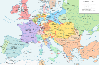
Map of Europe 1815, After the Congress of Vienna.
Sažetak
| Opis |
English: Europe 1815. Political situation after the Congress of Vienna in June 1815. Please don't alter the map when you think there is something not written or depicted correctly. Leave a message at the talk page of the file. After a verificiation and a possible discussion, I will upload a new map version with all new changes. This prevents an unnecessary waste of disk space and ensures a good result, aesthetically and content-wise. - The author. Español: Mapa de Europa en 1815. Situación política tras el Congreso de Viena en junio de 1815.
Deutsch: Europa 1815. Politische Lage nach dem Wiener Kongress im Juni 1815.
Bitte die Karte bei Änderungs- und Korrekturwünschen nicht selbst verändern, sondern eine Anmerkung im Diskussionsbereich der Bilddatei hinterlassen. Nach einer Prüfung und ggfs. Diskussion werden evtl. Änderungen von mir zusammengefasst eingearbeitet. Das vermeidet unnötige Speicherplatz-Verschwendung und gewährleistet ein ästhetisch ansprechendes und inhaltlich korrektes Ergebnis. - Der Urheber. Français : Carte de l'Europe en 1815. Situation politique après le Congrès de Vienne en juin 1815.
Italiano: Mappa dell'Europa nel 1815. Situazione politica dopo il Congresso di Vienna nel giugno 1815.
Русский: Карта Европы 1815 года. Политическая ситуация после Венского конгресса в июне 1815 года.
Português: Mapa da Europa em 1815. Situação política após o Congresso de Viena em junho de 1815. |
| Datum | |
| Izvor |
Vlastito djelo. Source of Information: Historical atlases – Map "1815 - L'Europe après le Congrès de Vienne" (Author unknown)(Link) – Ramsay Muir, George Philip (ed.): Philip's New School Atlas of Universal History, George Philip & Son, Ltd., London 1928 – Dr. Walter Leisering (ed.): Putzger Historischer Weltatlas, Cornelsen Verlag, Berlin 1992, ISBN 3-464-00176-8 – Bayerischer Schulbuch-Verlag (ed.): Großer Historischer Weltatlas, Dritter Teil, Neuzeit, Bayerischer Schulbuch-Verlag, München 1981, ISBN 3-7627-6021-7. – Prof. Dr. Hans-Erich Stier, Prof. Dr. Ernst Kirsten a. o. (ed.): Großer Atlas zur Weltgeschichte, Orbis Verlag, München 1990, ISBN 3-7627-6021-7 Other publications – Reinhard Stauber: Der Wiener Kongress, Böhlau Verlag, Wien/Köln/Weimar 2014, ISBN 978-3-8252-4095-0 – Thierry Lentz: 1815. Der Wiener Kongress und die Neugründung Europas, Siedler Verlag, München 2014, ISBN 978-3-8275-0027-4 |
| Autor | Alexander Altenhof |
| Ostale verzije |
|

Recompressed without quality loss with OptiPNG (1.36 MB > 1.06 MB)
Licenciranje
Ja, vlasnik autorskog prava ovog djela, ovdje ga objavljujem pod sljedećom licencom:
This file is licensed under the Creative Commons Attribution-Share Alike 4.0 International license.
- Slobodni ste:
- da dijelite – da kopirate, distributirate i prenosite djelo
- da remiksate – da prilagodite djelo
- Pod sljedećim uslovima:
- pripisivanje – Morate pripisati odgovarajuće autorske zasluge, osigurati link ka licenci i naznačiti jesu li napravljene izmjene. To možete uraditi na bilo koji razumni način, ali ne tako da se sugerira da davalac licence odobrava Vas ili Vašu upotrebu njegovog djela.
- dijeli pod istim uslovima – Ako mijenjate, transformišete ili nadograđujete ovaj materijal, morate ga objaviti i distribuirati samo pod istom ili sličnom licencom poput ove.

|
This map image could be re-created using vector graphics as an SVG file. This has several advantages; see Commons:Media for cleanup for more information. If an SVG form of this image is available, please upload it and afterwards replace this template with
{{vector version available|new image name}}.
It is recommended to name the SVG file “Europe 1815 map en.svg”—then the template Vector version available (or Vva) does not need the new image name parameter. |
Historija datoteke
Kliknite na datum/vrijeme da vidite verziju datoteke iz tog vremena.
| Datum/vrijeme | Smanjeni pregled | Dimenzije | Korisnik | Komentar | |
|---|---|---|---|---|---|
| trenutno | 01:36, 15 april 2017 | | 2.284 × 1.503 (1,08 MB) | KaterBegemot | Corrected "K. of Bavaria" caption / minor changes |
| 23:50, 11 septembar 2016 |  | 2.284 × 1.503 (1,36 MB) | KaterBegemot | Kingdom of Spain same green color like in the other maps | |
| 23:38, 11 septembar 2016 |  | 2.284 × 1.503 (1,06 MB) | KaterBegemot | Deleted black border at Austrian part of the German Confederation border, P. of Monaco smaller, corrected border at Tarnopol area, changed spacing of K. of Netherlands text | |
| 13:23, 20 juli 2016 |  | 2.284 × 1.503 (1,07 MB) | KaterBegemot | {{Information |Description ={{en|1=Europe 1815. Political situation after the Congress of Vienna in June 1815.<br> ''Please don't alter the map, when you think there something not written or depicted correclty. Leave a mes... |
Upotreba datoteke
Sljedeća stranica koristi ovu datoteku:
Globalna upotreba datoteke
Sljedeći wikiji koriste ovu datoteku:
- Upotreba na avk.wikipedia.org
- Upotreba na azb.wikipedia.org
- Upotreba na bg.wikipedia.org
- Upotreba na cs.wikipedia.org
- Upotreba na da.wikipedia.org
- Upotreba na el.wikipedia.org
- Upotreba na eml.wikipedia.org
- Upotreba na en.wikipedia.org
- Europe
- History of Europe
- 1810s
- History of Austria
- Congress of Vienna
- Napoleonic Wars
- History of the Czech lands
- Klemens von Metternich
- Karl August von Hardenberg
- Concert of Europe
- Former countries in Europe after 1815
- Balance of power (international relations)
- Monarchies in Europe
- Federal Convention (German Confederation)
- Portal:Czech Republic
- European balance of power
- 19th century
- International relations (1814–1919)
- Timeline of Karl Marx
- Timeline of the 19th century
- User:Falcaorib
- Secret Treaty of Vienna
- Talk:Europe/Archive 11
- User:SocratesGR
- Upotreba na en.wikibooks.org
- Upotreba na en.wikiquote.org
- Upotreba na eo.wikipedia.org
- Upotreba na eo.wikiquote.org
- Upotreba na es.wikipedia.org
- Upotreba na et.wikipedia.org
- Upotreba na eu.wikipedia.org
- Upotreba na fa.wikipedia.org
- Upotreba na fi.wikipedia.org
- Upotreba na fr.wikipedia.org
Pogledajte globalne upotrebe ove datoteke.