Datoteka:TSP Deutschland 3.png
Veća rezolucija nije dostupna.
TSP_Deutschland_3.png (326 × 350 piksela, veličina datoteke: 15 KB, MIME tip: image/png)
| Ova datoteka je s Wikimedia Commonsa. Opis s njene stranice opisa datoteke prikazan je ispod. Commons je skladište slobodnih medija i datoteka za sve projekte fondacije Wikimedia. Možete i Vi pomoći. |
Sažetak

|
This map of europe image could be re-created using vector graphics as an SVG file. This has several advantages; see Commons:Media for cleanup for more information. If an SVG form of this image is available, please upload it and afterwards replace this template with
{{vector version available|new image name}}.
It is recommended to name the SVG file “TSP Deutschland 3.svg”—then the template Vector version available (or Vva) does not need the new image name parameter. |
| Opis |
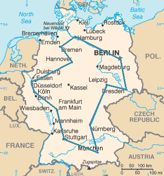
Kürzester Rundreiseweg durch die 15 größten Städte Deutschlands (14 sind genannt, Dortmund fehlt). Insgesamt sind 14!/2 = 43.589.145.600 verschiedene Wege möglich. |
| Datum | 21 oktobar 2005 (original upload date) |
| Izvor | https://www.cia.gov/cia/publications/factbook/maps/gm-map.gif |
| Autor | The original uploader was Kapitän Nemo at njemački Wikipedia. |
| Dopuštenje (Naknadno korištenje ove datoteke) |
https://www.cia.gov/cia/publications/factbook/docs/contributor_copyright.html |
Licenciranje
This image is in the public domain because it contains materials that originally came from the United States Central Intelligence Agency's World Factbook.
|
 |
Originalni zapisnik postavljanja
Transferred from de.wikipedia to Commons using CommonsHelper.
The original description page was here. All following user names refer to de.wikipedia.
- 2007-01-10 12:45 MrMonstar 328×352× (15511 bytes) {{Information |Beschreibung=Kürzester Rundreiseweg durch die 15 größten Städte Deutschlands. Insgesamt sind [[Fakultät_(Mathematik)|14!]]/2 = 43 589 145 600 verschiedene Wege möglich. |Quelle=Auf Basis der modifizierten [https://www.cia.gov/cia/publ
- 2005-10-21 10:44 Kapitän Nemo 328×352× (21053 bytes) == Beschreibung, Quelle und Lizenz == Optimaler Reiseweg eines Handlungsreisenden durch die 15 größten Städte Deutschlands. Auf Basis der modifizierten [http://www.cia.gov/cia/publications/factbook/maps/gm-map.gif CIA-Karte] selbst gezeichnet. == Liz
Historija datoteke
Kliknite na datum/vrijeme da vidite verziju datoteke iz tog vremena.
| Datum/vrijeme | Smanjeni pregled | Dimenzije | Korisnik | Komentar | |
|---|---|---|---|---|---|
| trenutno | 16:36, 1 januar 2021 | | 326 × 350 (15 KB) | Ras67 | frame removed |
| 05:50, 28 decembar 2008 |  | 328 × 352 (15 KB) | Amirki | {{Information |Description={{de|Kürzester Rundreiseweg durch die 15 größten Städte Deutschlands. Insgesamt sind 14!/2 = 43 589 145 600 verschiedene Wege möglich.}} |Source={{PD-user-w|de|wikipedia|MrMonstar}} |Date= |Author={{PD-user-w|de|wikipedia|M |
Upotreba datoteke
Sljedeća stranica koristi ovu datoteku:
Globalna upotreba datoteke
Sljedeći wikiji koriste ovu datoteku:
- Upotreba na ar.wikipedia.org
- Upotreba na bg.wikipedia.org
- Upotreba na ca.wikipedia.org
- Upotreba na cs.wikipedia.org
- Upotreba na de.wikipedia.org
- Upotreba na de.wikiversity.org
- Upotreba na de.wiktionary.org
- Upotreba na el.wikipedia.org
- Upotreba na en.wikipedia.org
- Upotreba na es.wikipedia.org
- Upotreba na fr.wikipedia.org
- Upotreba na gl.wikipedia.org
- Upotreba na he.wikipedia.org
- Upotreba na hu.wikipedia.org
- Upotreba na id.wikipedia.org
- Upotreba na it.wikipedia.org
- Upotreba na lt.wikipedia.org
- Upotreba na mwl.wikipedia.org
- Upotreba na nl.wikipedia.org
- Upotreba na nl.wiktionary.org
- Upotreba na pl.wikipedia.org
- Upotreba na pl.wiktionary.org
- Upotreba na pt.wikipedia.org
- Upotreba na ro.wikipedia.org
- Upotreba na ru.wikipedia.org
- Upotreba na simple.wikipedia.org
Pogledajte globalne upotrebe ove datoteke.