Datoteka:RS 1993.png

Veličina ovog prikaza: 631 × 600 piksela. Ostale rezolucije: 252 × 240 piksela | 505 × 480 piksela | 808 × 768 piksela | 1.077 × 1.024 piksela | 1.506 × 1.432 piksela.
Izvorna datoteka (1.506 × 1.432 piksela, veličina datoteke: 37 KB, MIME tip: image/png)
| Ova datoteka je s Wikimedia Commonsa. Opis s njene stranice opisa datoteke prikazan je ispod. Commons je skladište slobodnih medija i datoteka za sve projekte fondacije Wikimedia. Možete i Vi pomoći. |
Sažetak
| Opis |
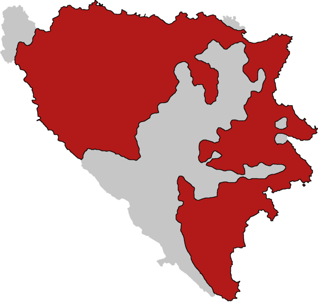
English: Territory controlled by Republika Srpska at the time of Vance-Owen Plan. Done according to the map presented by General Mladic during National Assembly session in May 1993 |
| Datum | |
| Izvor | Vlastito djelo |
| Autor | SRofSerbia |
Licenciranje
| This map is ineligible for copyright and therefore in the public domain, because it consists entirely of information that is common property and contains no original authorship. For more information, see Commons:Threshold of originality § Maps.
|
Historija datoteke
Kliknite na datum/vrijeme da vidite verziju datoteke iz tog vremena.
| Datum/vrijeme | Smanjeni pregled | Dimenzije | Korisnik | Komentar | |
|---|---|---|---|---|---|
| trenutno | 19:26, 17 novembar 2022 | | 1.506 × 1.432 (37 KB) | SRofSrb | Uploaded own work with UploadWizard |
Upotreba datoteke
Sljedeća stranica koristi ovu datoteku:
Globalna upotreba datoteke
Sljedeći wikiji koriste ovu datoteku:
- Upotreba na en.wikipedia.org
- Upotreba na es.wikipedia.org
- Upotreba na sr.wikipedia.org
- Upotreba na th.wikipedia.org