Datoteka:Map of Achaemenid Imperial Satraps (English Version).png

Izvorna datoteka (3.308 × 1.648 piksela, veličina datoteke: 653 KB, MIME tip: image/png)
| Ova datoteka je s Wikimedia Commonsa. Opis s njene stranice opisa datoteke prikazan je ispod. Commons je skladište slobodnih medija i datoteka za sve projekte fondacije Wikimedia. Možete i Vi pomoći. |
.png)
Sažetak
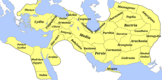
| Opis | A map of the satraps of the Achaemenid Empire showing their ancient names and the extent of their territory. (Borders are approximate.) | ||
| Datum | |||
| Izvor |
Vlastito djelo
Atlas Antiquus. Atlas zur Geschichte des Altertums. Gotha: Justus Perthes, 1909. (File)
And Design structure and overview: ACHAEMENID SATRAPIES. ENCYCLOPÆDIA IRANICA. Archived from the original on 2022-03-26. Retrieved on 2023-08-15.
File:Map of the Achaemenid Empire.jpg
|
||
| Autor | M.r ebrahim zadeh | ||
| Dopuštenje (Naknadno korištenje ove datoteke) |
|
||
| Ostale verzije |
Fa: Map of Achaemenid Imperial Satraps(fa)
1- File:Bābiruš (Satrapy of the Achaemenid Empire).png |
.png)
.png)
.png)
.png)
.png)
.png)
.png)
.png)
.png)
.png)
.png)
.png)
.png)
.png)
.png)
.png)
.png)
Licenciranje
- Slobodni ste:
- da dijelite – da kopirate, distributirate i prenosite djelo
- da remiksate – da prilagodite djelo
- Pod sljedećim uslovima:
- pripisivanje – Morate pripisati odgovarajuće autorske zasluge, osigurati link ka licenci i naznačiti jesu li napravljene izmjene. To možete uraditi na bilo koji razumni način, ali ne tako da se sugerira da davalac licence odobrava Vas ili Vašu upotrebu njegovog djela.
- dijeli pod istim uslovima – Ako mijenjate, transformišete ili nadograđujete ovaj materijal, morate ga objaviti i distribuirati samo pod istom ili sličnom licencom poput ove.
- ↑ cartography: Mohammad Pourkamal Drawing maps with the cooperation of selected employees of the drawing department of the organization Mapping and Geography Institute under the supervision of: Ebrahim Khalil Majidian Printing of maps in cooperation with the printing department of the Mapping Organization under the supervision of Shmuel Josephnia Prepared by: Institute of Geography, University of Tehran Persian writings: Mohammad Taghi Sarmast
Historija datoteke
Kliknite na datum/vrijeme da vidite verziju datoteke iz tog vremena.
| Datum/vrijeme | Smanjeni pregled | Dimenzije | Korisnik | Komentar | |
|---|---|---|---|---|---|
| trenutno | 11:28, 15 august 2023 | | 3.308 × 1.648 (653 KB) | M.r ebrahim zadeh | Uploaded own work with UploadWizard |
Upotreba datoteke
Sljedeća stranica koristi ovu datoteku:
Globalna upotreba datoteke
Sljedeći wikiji koriste ovu datoteku:
- Upotreba na ca.wikipedia.org
- Upotreba na en.wikipedia.org
- Upotreba na es.wikipedia.org
- Upotreba na fa.wikipedia.org
- Upotreba na it.wikipedia.org
- Frigia
- Paflagonia
- Nubia
- XXVII dinastia egizia
- Cilicia
- Corasmia
- Battriana
- Impero achemenide
- Caria
- Ionia
- Colchide
- Sogdiana
- Aracosia
- Regno di Gandhāra
- Arabia (satrapia)
- Partia
- Libia (satrapia)
- Cappadocia (satrapia)
- Lidia (satrapia)
- Media (satrapia)
- Ircania
- Armenia persiana
- Babilonia (provincia persiana)
- Carmania
- Assiria persiana
- Maka (satrapia)
- Margiana
- Satrapo
- Satrapie achemenidi
- Aria (satrapia)
- Gedrosia
- Drangiana
- Susiana
- Template:Province dell'Impero achemenide
- Sattagidia
- India (satrapia)
- Transeufratene
- Upotreba na ja.wikipedia.org
- Upotreba na ru.wikipedia.org
.png)