Datoteka:Great Lakes from space crop labeled.jpg
Veća rezolucija nije dostupna.
Great_Lakes_from_space_crop_labeled.jpg (792 × 469 piksela, veličina datoteke: 96 KB, MIME tip: image/jpeg)
| Ova datoteka je s Wikimedia Commonsa. Opis s njene stranice opisa datoteke prikazan je ispod. Commons je skladište slobodnih medija i datoteka za sve projekte fondacije Wikimedia. Možete i Vi pomoći. |
Sažetak
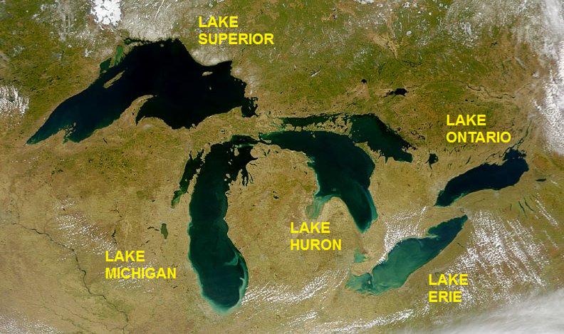
| Opis | Satellite image of the Great Lakes from space |
| Datum | |
| Izvor | http://visibleearth.nasa.gov/view_rec.php?id=793 |
| Autor | SeaWiFS Project, NASA/Goddard Space Flight Center, and ORBIMAGE; cropped and labeled by Beyond My Ken (talk) 05:49, 11 September 2012 (UTC) |
| Ostale verzije |
  |
Licenciranje
| This image is from the Sea-viewing Wide Field-of-view Sensor (SeaWiFS) Project and more than 5 years old.
Satellite data captured by the SeaWIFS sensor are released into the public domain 5 years after capture. Data less than five years old can be re-used only for educational or scientific purposes; any commercial use of such images must be coordinated with GeoEye. [1] |
| This work has been released into the public domain by its copyright holder, GeoEye. This applies worldwide. U nekim državama ovo zakonski nije moguće; u tom slučaju: GeoEye dopušta svima pravo korištenja ovog rada u bilo koju svrhu, bez ikakvih uslova, osim ako su takvi uslovi zakonski neophodni.
|
Historija datoteke
Kliknite na datum/vrijeme da vidite verziju datoteke iz tog vremena.
| Datum/vrijeme | Smanjeni pregled | Dimenzije | Korisnik | Komentar | |
|---|---|---|---|---|---|
| trenutno | 07:49, 11 septembar 2012 | | 792 × 469 (96 KB) | Beyond My Ken | == {{int:filedesc}} == {{Information |Description= Satellite image of the Great Lakes from space |Source= http://visibleearth.nasa.gov/view_rec.php?id=793 |Date= 2000-04-24 |Author= SeaWiFS Project, NASA/Goddard Space Flight Center, and ORBIMAGE; cropp... |
Upotreba datoteke
Sljedeća stranica koristi ovu datoteku:
Globalna upotreba datoteke
Sljedeći wikiji koriste ovu datoteku:
- Upotreba na am.wikipedia.org
- Upotreba na as.wikipedia.org
- Upotreba na be.wikipedia.org
- Upotreba na bh.wikipedia.org
- Upotreba na bn.wikipedia.org
- Upotreba na bxr.wikipedia.org
- Upotreba na ce.wikipedia.org
- Upotreba na ckb.wikipedia.org
- Upotreba na en.wikipedia.org
- Upotreba na en.wikibooks.org
- Upotreba na eo.wikipedia.org
- Upotreba na eu.wikipedia.org
- Upotreba na gl.wikipedia.org
- Upotreba na he.wikipedia.org
- Upotreba na he.wikivoyage.org
- Upotreba na hy.wikipedia.org
- Upotreba na ilo.wikipedia.org
- Upotreba na lfn.wikipedia.org
- Upotreba na mai.wikipedia.org
- Upotreba na ne.wikipedia.org
- Upotreba na new.wikipedia.org
- Upotreba na pa.wikipedia.org
- Upotreba na pt.wikipedia.org
- Upotreba na udm.wikipedia.org
- Upotreba na uz.wikipedia.org