Datoteka:Earth 720Ma.gif

Veličina ovog prikaza: 800 × 450 piksela. Ostale rezolucije: 320 × 180 piksela | 640 × 360 piksela | 1.024 × 576 piksela | 1.280 × 720 piksela | 1.920 × 1.080 piksela.
Izvorna datoteka (1.920 × 1.080 piksela, veličina datoteke: 211 KB, MIME tip: image/gif, stalno iznova, 0,5 s)
| Ova datoteka je s Wikimedia Commonsa. Opis s njene stranice opisa datoteke prikazan je ispod. Commons je skladište slobodnih medija i datoteka za sve projekte fondacije Wikimedia. Možete i Vi pomoći. |
Sažetak
| Opis |
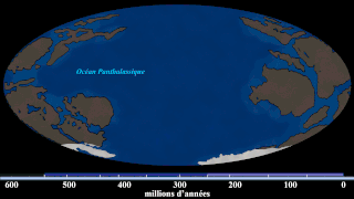
English: Hand-drawn images of the Earth around that timeframe. (Based on the first frame of the source GIF, which says this is 740 Ma. But i re-estimate this into around ~720 Ma based on the position of the continents with new Algol's video (at 9:20), which also has new and updated sources) With Algol's video and given that yellow stripe (that estimates the time) doesn't give when it is happening, i gave this illustration with a new estimate. Since this is an estimate, the exact time cannot be measured. Note: this is not a map of Rodinia, this is a map when Rodinia is breaking up at 720 Ma. |
| Datum | |
| Izvor | File:Continental Drift (740 million-to-Today).gif |
| Autor | SebM123 |
.gif)
Licenciranje
| Ova datoteka je dostupna pod licencom Creative Commons CC0 1.0 Univerzalnom Posvetom Javne Domene. | |
| Osoba koja je učestvovala u radu na ovom dokumentu posvetila je rad javnoj domeni odricanjem od svih svojih prava na taj rad širom svijeta po zakonu o autorskim pravima i svim povezanim zakonskim pravima koja bi imao/imala, u mjeri dopuštenoj zakonom. Možete kopirati, mijenjati, distribuirati i prilagođavati rad, čak i u komercijalne svrhe, bez traženja dopuštenja.
|
Historija datoteke
Kliknite na datum/vrijeme da vidite verziju datoteke iz tog vremena.
| Datum/vrijeme | Smanjeni pregled | Dimenzije | Korisnik | Komentar | |
|---|---|---|---|---|---|
| trenutno | 06:35, 22 maj 2020 | | 1.920 × 1.080 (211 KB) | MarioJump83 | Uploaded a work by SebM123 from File:Continental Drift (740 million-to-Today).gif with UploadWizard |
.gif)
Upotreba datoteke
Nema stranica koje koriste ovu datoteku.
Globalna upotreba datoteke
Sljedeći wikiji koriste ovu datoteku:
- Upotreba na fi.wikibooks.org
- Upotreba na pt.wikipedia.org
- Upotreba na tr.wikipedia.org
- Upotreba na www.wikidata.org