Datoteka:Bo-map.png
Veća rezolucija nije dostupna.
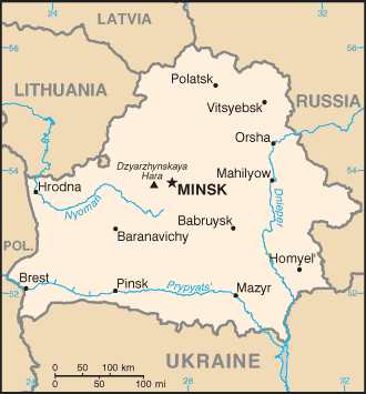
Bo-map.png (330 × 355 piksela, veličina datoteke: 11 KB, MIME tip: image/png)
| Ova datoteka je s Wikimedia Commonsa. Opis s njene stranice opisa datoteke prikazan je ispod. Commons je skladište slobodnih medija i datoteka za sve projekte fondacije Wikimedia. Možete i Vi pomoći. |
Belarus map from CIA World Factbook
This image is in the public domain because it contains materials that originally came from the United States Central Intelligence Agency's World Factbook.
|
 |

|
This map image could be re-created using vector graphics as an SVG file. This has several advantages; see Commons:Media for cleanup for more information. If an SVG form of this image is available, please upload it and afterwards replace this template with
{{vector version available|new image name}}.
It is recommended to name the SVG file “Bo-map.svg”—then the template Vector version available (or Vva) does not need the new image name parameter. |
Historija datoteke
Kliknite na datum/vrijeme da vidite verziju datoteke iz tog vremena.
| Datum/vrijeme | Smanjeni pregled | Dimenzije | Korisnik | Komentar | |
|---|---|---|---|---|---|
| trenutno | 22:28, 27 novembar 2004 | | 330 × 355 (11 KB) | Kneiphof | CIA Belarus map |
Upotreba datoteke
Sljedeća stranica koristi ovu datoteku:
Globalna upotreba datoteke
Sljedeći wikiji koriste ovu datoteku:
- Upotreba na be.wikipedia.org
- Upotreba na bg.wikipedia.org
- Upotreba na bn.wikipedia.org
- Upotreba na dsb.wikipedia.org
- Upotreba na el.wikipedia.org
- Upotreba na en.wikipedia.org
- Upotreba na es.wikipedia.org
- Upotreba na eu.wikipedia.org
- Upotreba na fa.wikipedia.org
- Upotreba na ff.wikipedia.org
- Upotreba na gag.wikipedia.org
- Upotreba na hu.wikipedia.org
- Upotreba na hu.wiktionary.org
- Upotreba na ka.wikipedia.org
- Upotreba na ko.wikipedia.org
- Upotreba na mk.wikipedia.org
- Upotreba na mn.wikipedia.org
- Upotreba na mr.wikipedia.org
- Upotreba na nap.wikipedia.org
- Upotreba na nl.wiktionary.org
- Upotreba na nn.wikipedia.org
- Upotreba na no.wikipedia.org
- Upotreba na ro.wikipedia.org
- Upotreba na ru.wikipedia.org
- Upotreba na ru.wiktionary.org
- Upotreba na sh.wikipedia.org
- Upotreba na simple.wikipedia.org
- Upotreba na sl.wikipedia.org
- Upotreba na sr.wikipedia.org
- Upotreba na sw.wikipedia.org
- Upotreba na th.wikipedia.org
- Upotreba na tr.wikipedia.org
- Upotreba na udm.wikipedia.org
- Upotreba na uk.wikipedia.org
- Upotreba na xmf.wikipedia.org
- Upotreba na zh.wikipedia.org