Datoteka:Bay-of-Piran maritime-boundary-dispute.jpg
Veća rezolucija nije dostupna.
Bay-of-Piran_maritime-boundary-dispute.jpg (709 × 600 piksela, veličina datoteke: 160 KB, MIME tip: image/jpeg)
| Ova datoteka je s Wikimedia Commonsa. Opis s njene stranice opisa datoteke prikazan je ispod. Commons je skladište slobodnih medija i datoteka za sve projekte fondacije Wikimedia. Možete i Vi pomoći. |
Sažetak

|
File:Bay-of-Piran maritime-boundary-dispute.svg is a vector version of this file. It should be used in place of this JPG file when not inferior.
File:Bay-of-Piran maritime-boundary-dispute.jpg → File:Bay-of-Piran maritime-boundary-dispute.svg
For more information, see Help:SVG. |
 |
| Opis |
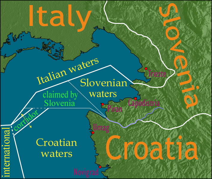
English: Map showing a diplomatic dispute resulting from Slovenia's desire to obtain a direct corridor from its own territorial waters to international waters, to avoid the necessity of Slovenian ships having to sail through the territorial waters of any other country to get to the high seas. Slovenia's only seacoast is in the Bay of Piran / Gulf of Trieste (as shown in this map), and its only commercial seaport is Capodistria / Koper (the eastern of the two red dots in Slovenia on this map), while Italy and Croatia both have long seacoasts outside the area shown in this map.
Slovenia's claim to the area labelled with green text, and the existence of a corridor to international waters, would have been allowed by Croatia under the Drnovšek-Račan agreement, but this was never ratified by either countries' parliaments. This is an English version of image de:Bild:Grenzstreit-Bucht-von-Piran.jpg, created using image Image:BorderDispute_BayOfPiran_blank.png. Raw Adobe Photoshop PSD files (with all text on different type layers) are available on request. |
| Datum | |
| Izvor | File:BorderDispute_BayOfPiran_blank.png |
| Autor |
|
| Dopuštenje (Naknadno korištenje ove datoteke) |
The underlying source Image:BorderDispute_BayOfPiran_blank.png is declared to be GFDL, while I declare my changes to it to be PD. |
| Ostale verzije | Derivative works of this file: Bay-of-Piran maritime-boundary-dispute.svg |

Licenciranje

|
Dozvoljeno je kopirati, distribuirati i/ili mijenjati ovaj članak pod uslovima navedenim u GNU licenci za slobodnu dokumentaciju, verzija 1.2 ili kasnijom verzijom izdatom od Free Software Foundation; bez nepromjenljivih dijelova, te bez sadržaja na naslovnoj i zadnjoj strani. Kopija licence se nalazi pod poglavljem GNU Free Documentation License. |
| Ova datoteka je licencirana pod Creative Commons Attribution-Share Alike 3.0 neportiranom licencom. | ||
| ||
| Ova oznaka licence je dodana na ovu datoteku kao dio GFDL ažuriranja licence. |
Historija datoteke
Kliknite na datum/vrijeme da vidite verziju datoteke iz tog vremena.
| Datum/vrijeme | Smanjeni pregled | Dimenzije | Korisnik | Komentar | |
|---|---|---|---|---|---|
| trenutno | 16:17, 8 januar 2007 | | 709 × 600 (160 KB) | AnonMoos | adding city names |
| 20:13, 24 decembar 2006 |  | 709 × 600 (156 KB) | AnonMoos | deepening colors slightly | |
| 16:00, 14 decembar 2006 |  | 709 × 600 (156 KB) | AnonMoos | Map showing diplomatic dispute over Slovenia's desire to obtain a direct corridor from its own territorial waters to international waters, to avoid Slovenian ships having to sail through the territorial waters of any other country to get to the high seas. |
Upotreba datoteke
Nema stranica koje koriste ovu datoteku.
Globalna upotreba datoteke
Sljedeći wikiji koriste ovu datoteku:
- Upotreba na de.wikipedia.org
- Upotreba na en.wikipedia.org
- Upotreba na en.wikinews.org
- Upotreba na es.wikipedia.org
- Upotreba na fy.wikipedia.org
- Upotreba na it.wikipedia.org
- Upotreba na ja.wikipedia.org
- Upotreba na ko.wikipedia.org
- Upotreba na pl.wikipedia.org
- Upotreba na sl.wikipedia.org
- Upotreba na zh.wikipedia.org