Datoteka:World empires and colonies around World War I.png
Veličina ovog prikaza: 800 × 323 piksela. Ostale rezolucije: 320 × 129 piksela | 640 × 258 piksela | 1.554 × 627 piksela.
Izvorna datoteka (1.554 × 627 piksela, veličina datoteke: 63 KB, MIME tip: image/png)
| Ova datoteka je s Wikimedia Commonsa. Opis s njene stranice opisa datoteke prikazan je ispod. Commons je skladište slobodnih medija i datoteka za sve projekte fondacije Wikimedia. Možete i Vi pomoći. |
Sažetak
| Opis |
English:
|
| Datum | 2 august 2007 (original upload date) |
| Izvor | Taken from wikipedia map |
| Autor | Vidi ispod. |
| Ostale verzije |
.png)

|
This historical map image could be re-created using vector graphics as an SVG file. This has several advantages; see Commons:Media for cleanup for more information. If an SVG form of this image is available, please upload it and afterwards replace this template with
{{vector version available|new image name}}.
It is recommended to name the SVG file “World empires and colonies around World War I.svg”—then the template Vector version available (or Vva) does not need the new image name parameter. |
Licenciranje
Ishvara7 at engleski Wikipedia, vlasnik autorskog prava ovog djela, ovdje ga objavljujem pod sljedećim licencama:

|
Dozvoljeno je kopirati, distribuirati i/ili mijenjati ovaj članak pod uslovima navedenim u GNU licenci za slobodnu dokumentaciju, verzija 1.2 ili kasnijom verzijom izdatom od Free Software Foundation; bez nepromjenljivih dijelova, te bez sadržaja na naslovnoj i zadnjoj strani. Kopija licence se nalazi pod poglavljem GNU Free Documentation License. |
| Ova datoteka je licencirana pod Creative Commons Attribution-Share Alike 3.0 neportiranom licencom. | ||
| Pripisivanje: Ishvara7 at engleski Wikipedia | ||
| ||
| Ova oznaka licence je dodana na ovu datoteku kao dio GFDL ažuriranja licence. |
Ova datoteka je licencirana pod Creative Commons Attribution-Share Alike 2.5 generičkom, 2.0 generičkom i 1.0 generičkom licencom.
Pripisivanje: Ishvara7 at engleski Wikipedia
- Slobodni ste:
- da dijelite – da kopirate, distributirate i prenosite djelo
- da remiksate – da prilagodite djelo
- Pod sljedećim uslovima:
- pripisivanje – Morate pripisati odgovarajuće autorske zasluge, osigurati link ka licenci i naznačiti jesu li napravljene izmjene. To možete uraditi na bilo koji razumni način, ali ne tako da se sugerira da davalac licence odobrava Vas ili Vašu upotrebu njegovog djela.
- dijeli pod istim uslovima – Ako mijenjate, transformišete ili nadograđujete ovaj materijal, morate ga objaviti i distribuirati samo pod istom ili sličnom licencom poput ove.
Možete odabrati licencu po vašem izboru.
Originalni zapisnik postavljanja
Transferred from en.wikipedia to Commons by M0rphzone.
The original description page was here. All following user names refer to en.wikipedia.
- 2008-08-17 11:30 Scooter20 1554×627× (72711 bytes) + Added Romania
- 2007-09-09 06:32 Swedish fusilier 1554×627× (72758 bytes) *Original Author: [[Ishvara7]], edited by [[Swedish fusilier]] to correct the colouring of several southern Indian Ocean islands (eg. [[Kerguelen]]) which should be coloured as French possesions. *Taken from Wikipedia map *Nations involved with imperialis
- 2007-08-11 12:48 Taktser 1554×627× (72824 bytes)
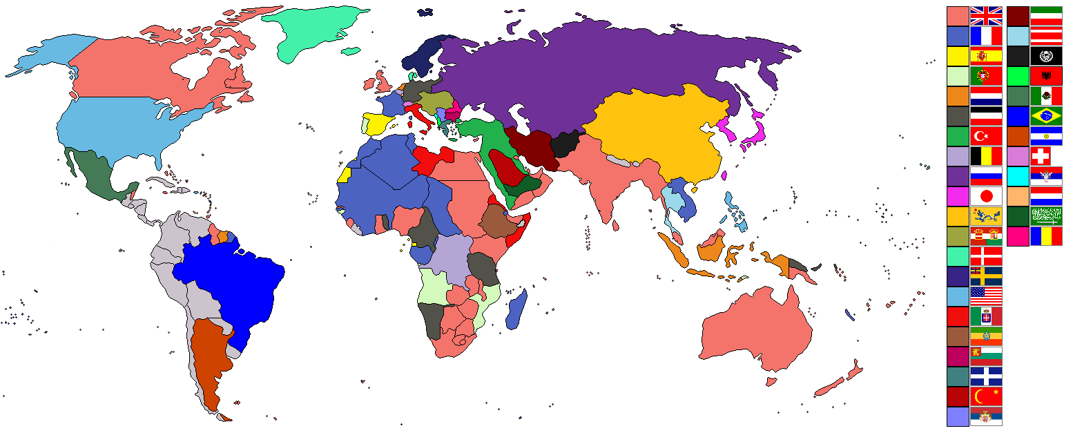
- 2007-08-02 22:04 Ishvara7 1554×627× (73211 bytes) *Ishvara7 *Taken from wikipedia map *Dated around 1900 *Nations involved with imperialism, directly or indirectly, are colored. Meant to potray the world around the time of WWI. *In case anyone wonders, the red flag with the yellow crescent and star is th
The original description page was here. All following user names refer to en.wikipedia.
- 2007-08-02 21:15 Ishvara7 1554×627× (72719 bytes) *Ishvara7 *Taken from wikipedia map *Not all nations are colored. Only ones with the most importance related to colonialism, interaction with colonial powers, and WWI. *Map dates to the year 1900.
The original description page was here. All following user names refer to en.wikipedia.
- 2007-08-02 19:27 Ishvara7 1554×627× (72762 bytes) *Ishvara7 *New nations labled according to importance within world politics and WWI. *Taken from old colonialism wikipedia map
The original description page was here. All following user names refer to en.wikipedia.
- 2007-08-01 01:36 Ishvara7 1458×627× (63275 bytes) *Ishvara7 *Taken from old colonial map on wikipeia and outlined *Better images of flags and includes Ethiopian Empire *yes, it did take forever
Historija datoteke
Kliknite na datum/vrijeme da vidite verziju datoteke iz tog vremena.
| Datum/vrijeme | Smanjeni pregled | Dimenzije | Korisnik | Komentar | |
|---|---|---|---|---|---|
| trenutno | 11:09, 8 novembar 2021 | 1.554 × 627 (63 KB) | Randomastwritter | ogaden | |
| 04:48, 5 decembar 2012 | 1.554 × 627 (37 KB) | OjdvQ9fNJWl | Uploaded optimized image of first version here at Commons (latest on Wikipedia). File desc for prev version: *Ishvara7 *Taken from wikipedia map *Not all nations are colored. Only ones with the most importance related to colonialism, interaction with c... | ||
| 04:42, 5 decembar 2012 | 1.554 × 627 (71 KB) | OjdvQ9fNJWl | Old version from Wikipedia (File:Imperialism.png) dated 21:15, 2 August 2007 by Ishvara7. File desc for prev: *New nations labled according to importance within world politics and WWI. *Taken from old colonialism wikipedia map. | ||
| 04:29, 5 decembar 2012 | 1.554 × 627 (71 KB) | OjdvQ9fNJWl | Old version (File:Imperialism6.png) from Wikipedia by Ishvara7 at 19:27, 2 August 2007. File desc for prev upload: *Taken from old colonial map on wikipeia and outlined *Better images of flags and includes Ethiopian Empire *yes, it did take forever. Fi... | ||
| 04:25, 5 decembar 2012 |  | 1.458 × 627 (62 KB) | OjdvQ9fNJWl | Uploaded old image version from http://en.wikipedia.org/wiki/File:Imperialism_5.png uploaded by Ishvara7 at 01:36, 1 August 2007 (UTC) | |
| 04:03, 5 decembar 2012 | 1.554 × 627 (71 KB) | OjdvQ9fNJWl | {{Information |Description={{en|*Taken from wikipedia map. *Dated around 1900 (shows Italian - although the flag is not correct - North Africa post 1910 and Austro-Hungarian Empire circa WW1). British territories o... |
Upotreba datoteke
Sljedeća stranica koristi ovu datoteku:
Globalna upotreba datoteke
Sljedeći wikiji koriste ovu datoteku:
- Upotreba na ar.wikipedia.org
- Upotreba na ckb.wikipedia.org
- Upotreba na en.wikipedia.org
- Upotreba na fr.wikipedia.org
- Upotreba na km.wikipedia.org
- Upotreba na pnb.wikipedia.org
- Upotreba na ur.wikipedia.org