Datoteka:Vinnytsia oblast detail map.png
Vinnytsia_oblast_detail_map.png (341 × 379 piksela, veličina datoteke: 21 KB, MIME tip: image/png)
| Ova datoteka je s Wikimedia Commonsa. Opis s njene stranice opisa datoteke prikazan je ispod. Commons je skladište slobodnih medija i datoteka za sve projekte fondacije Wikimedia. Možete i Vi pomoći. |
Sažetak

|
This locator map image could be re-created using vector graphics as an SVG file. This has several advantages; see Commons:Media for cleanup for more information. If an SVG form of this image is available, please upload it and afterwards replace this template with
{{vector version available|new image name}}.
It is recommended to name the SVG file “Vinnytsia oblast detail map.svg”—then the template Vector version available (or Vva) does not need the new image name parameter. |
| Opis |
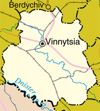
English: Map of en:Vinnytsia Oblast, en:Ukraine
Adapted from http://www.un.org/Depts/Cartographic/map/profile/ukraine.pdf |
| Datum | 20 maj 2005 (original upload date) |
| Izvor | Transferred from en.wikipedia to Commons by Drilnoth using CommonsHelper. |
| Autor | The original uploader was ChrisO at engleski Wikipedia. |
Licenciranje
| This image is a map derived from a United Nations map.
Unless stated otherwise, UN maps are to be considered in the public domain. This applies worldwide. UN maps are, in principle, open source material and you can use them in your work or for making your own map. UN requests however that you delete the UN name, logo and reference number upon any modification to the map. Content of your map will be your responsibility. You can state in your publication, if you wish, something like: based on UN map … (map name, map number, revision number and date). See: Geospatial Information Section. And: Geospatial, location data for a better world. |
 |
Originalni zapisnik postavljanja
- 2005-05-20 21:07 ChrisO 341×379× (22014 bytes) Map of [[Vinnytsia Oblast]], [[Ukraine]] Adapted from http://www.un.org/Depts/Cartographic/map/profile/ukraine.pdf {{UN_map}} {{PD}}
Historija datoteke
Kliknite na datum/vrijeme da vidite verziju datoteke iz tog vremena.
| Datum/vrijeme | Smanjeni pregled | Dimenzije | Korisnik | Komentar | |
|---|---|---|---|---|---|
| trenutno | 14:41, 31 mart 2009 | | 341 × 379 (21 KB) | File Upload Bot (Magnus Manske) | {{BotMoveToCommons|en.wikipedia|year={{subst:CURRENTYEAR}}|month={{subst:CURRENTMONTHNAME}}|day={{subst:CURRENTDAY}}}} {{Information |Description={{en|Map of en:Vinnytsia Oblast, en:Ukraine Adapted from http://www.un.org/Depts/Cartographic/map |
Upotreba datoteke
Sljedeća stranica koristi ovu datoteku:
Globalna upotreba datoteke
Sljedeći wikiji koriste ovu datoteku:
- Upotreba na ast.wikipedia.org
- Upotreba na en.wikipedia.org
- Upotreba na eo.wikipedia.org
- Upotreba na es.wikipedia.org
- Upotreba na hr.wikipedia.org
- Upotreba na pt.wikipedia.org
- Upotreba na sco.wikipedia.org
- Upotreba na sh.wikipedia.org
- Upotreba na ta.wikipedia.org