Datoteka:United States Minor Outlying Islands.png
Veličina ovog prikaza: 800 × 577 piksela. Ostale rezolucije: 320 × 231 piksela | 640 × 461 piksela | 1.011 × 729 piksela.
Izvorna datoteka (1.011 × 729 piksela, veličina datoteke: 89 KB, MIME tip: image/png)
| Ova datoteka je s Wikimedia Commonsa. Opis s njene stranice opisa datoteke prikazan je ispod. Commons je skladište slobodnih medija i datoteka za sve projekte fondacije Wikimedia. Možete i Vi pomoći. |

|
This map image could be re-created using vector graphics as an SVG file. This has several advantages; see Commons:Media for cleanup for more information. If an SVG form of this image is available, please upload it and afterwards replace this template with
{{vector version available|new image name}}.
It is recommended to name the SVG file “United States Minor Outlying Islands.svg”—then the template Vector version available (or Vva) does not need the new image name parameter. |
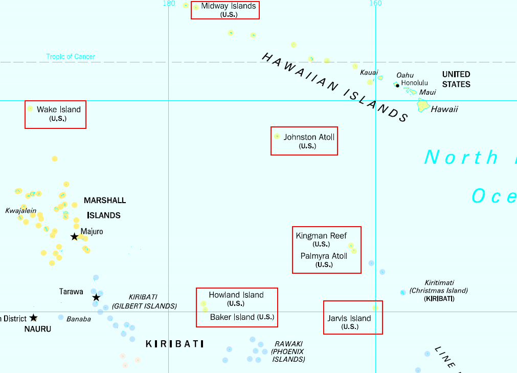
English: United States Minor Outlying Islands in the Pacific Ocean higlighted from public domain map. Note: There is also Navassa Island in the Caribbean.
This work is in the public domain in the United States because it is a work prepared by an officer or employee of the United States Government as part of that person’s official duties under the terms of Title 17, Chapter 1, Section 105 of the US Code.
Note: This only applies to original works of the Federal Government and not to the work of any individual U.S. state, territory, commonwealth, county, municipality, or any other subdivision. This template also does not apply to postage stamp designs published by the United States Postal Service since 1978. (See § 313.6(C)(1) of Compendium of U.S. Copyright Office Practices). It also does not apply to certain US coins; see The US Mint Terms of Use.
|
 | |
| Ova datoteka je identificirana kao slobodna od poznatih ograničenja po zakonu o autorskim pravima, uključujući sva povezana i srodna prava. | ||
Historija datoteke
Kliknite na datum/vrijeme da vidite verziju datoteke iz tog vremena.
| Datum/vrijeme | Smanjeni pregled | Dimenzije | Korisnik | Komentar | |
|---|---|---|---|---|---|
| trenutno | 19:20, 3 mart 2009 | | 1.011 × 729 (89 KB) | Kmusser | Changed the Midway box so that it doesn't include Kure Atoll |
| 12:34, 7 mart 2007 |  | 1.011 × 729 (68 KB) | Roke~commonswiki | United States Minor Outlying Islands higlighted from [http://www.lib.utexas.edu/maps/islands_oceans_poles/oceania_pol_97.jpg public domain map] {{PD-PCL|/oceania_pol_97.jpg|islands_oceans_poles}} |
Upotreba datoteke
Sljedeće 2 stranice koriste ovu datoteku:
Globalna upotreba datoteke
Sljedeći wikiji koriste ovu datoteku:
- Upotreba na af.wikipedia.org
- Upotreba na ar.wikipedia.org
- Upotreba na arz.wikipedia.org
- Upotreba na az.wikipedia.org
- Upotreba na bg.wikipedia.org
- Upotreba na ca.wikipedia.org
- Upotreba na cy.wikipedia.org
- Upotreba na da.wikipedia.org
- Upotreba na de.wikipedia.org
- Upotreba na el.wikipedia.org
- Upotreba na en.wikipedia.org
- Upotreba na eo.wikipedia.org
- Upotreba na es.wikipedia.org
- Upotreba na fa.wikipedia.org
- Upotreba na fi.wikipedia.org
- Upotreba na fo.wikipedia.org
- Upotreba na fr.wikipedia.org
- Upotreba na fr.wiktionary.org
- Upotreba na ia.wikipedia.org
- Upotreba na id.wikipedia.org
- Upotreba na incubator.wikimedia.org
- Upotreba na ka.wikipedia.org
- Upotreba na kk.wikipedia.org
- Upotreba na ko.wikipedia.org
- Upotreba na lb.wikipedia.org
- Upotreba na lv.wikipedia.org
- Upotreba na mk.wikipedia.org
- Upotreba na nl.wikipedia.org
- Upotreba na no.wikipedia.org
- Upotreba na pl.wikipedia.org
- Upotreba na pnb.wikipedia.org
- Upotreba na pt.wikipedia.org
- Upotreba na ru.wikipedia.org
Pogledajte globalne upotrebe ove datoteke.