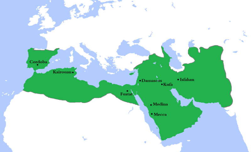
Datoteka:Umayyad750ADloc.png

Veličina ovog prikaza: 800 × 487 piksela. Ostale rezolucije: 320 × 195 piksela | 640 × 390 piksela | 1.024 × 624 piksela | 1.481 × 902 piksela.
Izvorna datoteka (1.481 × 902 piksela, veličina datoteke: 44 KB, MIME tip: image/png)
Historija datoteke
Kliknite na datum/vrijeme da vidite verziju datoteke iz tog vremena.
| Datum/vrijeme | Smanjeni pregled | Dimenzije | Korisnik | Komentar | |
|---|---|---|---|---|---|
| trenutno | 00:23, 5 august 2020 |  | 1.481 × 902 (44 KB) | Ozan33Ankara | Corrected borders based on: The expansion of the Muslim Caliphate until 750, from William R. Shepherd's Historical Atlas. |
| 17:24, 11 april 2013 |  | 1.481 × 902 (30 KB) | HistoryofIran | {{subst:Upload marker added by en.wp UW}} {{Information |Description = {{en|Made the map more presice, the Umayyads never controlled Tabaristan because of the Dabuyid dynasty, but the Abbasids did that later.}} |Source = http://en.wikipedia.org/wiki/Fi... | |
| 17:55, 10 april 2013 |  | 1.481 × 902 (37 KB) | Khateeb88 | Added the major cities of the Umayyad Caliphate: Damascus, Kufa, Isfahan, Mecca, Medina, Fustat, Kairouan, and Cordoba. | |
| 17:54, 10 april 2013 |  | 1.481 × 902 (37 KB) | Khateeb88 | Added the major cities of the Umayyad Caliphate: Damascus, Kufa, Isfahan, Mecca, Medina, Fustat, Kairouan, and Cordoba. | |
| 18:17, 22 april 2009 |  | 1.481 × 902 (50 KB) | Gabagool | some corrections.. | |
| 18:10, 20 april 2009 |  | 1.481 × 902 (50 KB) | Gabagool | {{Information |Description={{en|1=Locator map for the Umayyad Caliphate at its greatest extent, c. AD 750. (Partially based on ''Atlas of World History'' (2007) - World 500-750, map.)}} |Source=Own work by uploader |Author=Gabagool / Ja |
Upotreba datoteke
Sljedeća stranica koristi ovu datoteku:
Globalna upotreba datoteke
Sljedeći wikiji koriste ovu datoteku:
- Upotreba na af.wikipedia.org
- Upotreba na als.wikipedia.org
- Upotreba na an.wikipedia.org
- Upotreba na ast.wikipedia.org
- Upotreba na av.wikipedia.org
- Upotreba na az.wikipedia.org
- Upotreba na ba.wikipedia.org
- Upotreba na be.wikipedia.org
- Upotreba na bg.wikipedia.org
- Upotreba na bn.wikipedia.org
- Upotreba na br.wikipedia.org
- Upotreba na ca.wikipedia.org
- Upotreba na ckb.wikipedia.org
- Upotreba na cy.wikipedia.org
- Upotreba na da.wikipedia.org
- Upotreba na de.wikipedia.org
- Upotreba na el.wikipedia.org
- Upotreba na en.wikipedia.org
- History of Islam
- 744
- Arabian Peninsula
- Harran
- Saudi Arabia
- Core countries
- Mauretania Caesariensis
- Mauretania Tingitana
- Battle of Carthage (698)
- Wikipedia:Articles for deletion/Log/2009 June 18
- Wikipedia:Articles for deletion/Armenia–Spain relations
- User:BomBom/List of caliphs
- User:Sobreira/Religion
- Umayyad architecture
Pogledajte globalne upotrebe ove datoteke.

