Datoteka:Umayyad750ADloc-ar.png

Veličina ovog prikaza: 800 × 487 piksela. Ostale rezolucije: 320 × 195 piksela | 640 × 390 piksela | 1.024 × 624 piksela | 1.481 × 902 piksela.
Izvorna datoteka (1.481 × 902 piksela, veličina datoteke: 46 KB, MIME tip: image/png)
| Ova datoteka je s Wikimedia Commonsa. Opis s njene stranice opisa datoteke prikazan je ispod. Commons je skladište slobodnih medija i datoteka za sve projekte fondacije Wikimedia. Možete i Vi pomoći. |
Sažetak
| Opis |
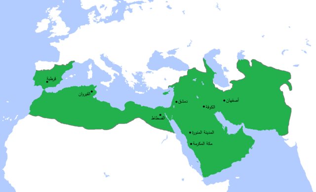
العربية: خارطة تُظهر المساحة التي امتدَّت عليها الدولة الأُمويَّة في أقصى اتساعها وذُروة قوَّتها، حوالي سنة 750م. (الرسم مبني بشكلٍ جُزئيّ على كتاب "أطلس تاريخ العالم" (2007) - العالم ما بين سنتيّ 500 و750م، الخارطة.) |
| Datum | (UTC) |
| Izvor |
This file was derived from: Umayyad750ADloc.png: |
| Autor |
|
| This is a retouched picture, which means that it has been digitally altered from its original version. Modifications: Translated to Arabic - عُرِّبت. The original can be viewed here: Umayyad750ADloc.png:
|
Licenciranje
Ja, vlasnik autorskog prava ovog djela, ovdje ga objavljujem pod sljedećom licencom:
Ova datoteka je licencirana pod Creative Commons Attribution 3.0 neportiranom licencom.
- Slobodni ste:
- da dijelite – da kopirate, distributirate i prenosite djelo
- da remiksate – da prilagodite djelo
- Pod sljedećim uslovima:
- pripisivanje – Morate pripisati odgovarajuće autorske zasluge, osigurati link ka licenci i naznačiti jesu li napravljene izmjene. To možete uraditi na bilo koji razumni način, ali ne tako da se sugerira da davalac licence odobrava Vas ili Vašu upotrebu njegovog djela.
Originalni zapisnik postavljanja
This image is a derivative work of the following images:
- File:Umayyad750ADloc.png licensed with Cc-by-3.0
- 2013-04-11T15:24:29Z HistoryofIran 1481x902 (30417 Bytes) {{subst:Upload marker added by en.wp UW}} {{Information |Description = {{en|Made the map more presice, the Umayyads never controlled Tabaristan because of the Dabuyid dynasty, but the Abbasids did that later.}} |Source = http
- 2013-04-10T15:55:41Z Khateeb88 1481x902 (38391 Bytes) Added the major cities of the Umayyad Caliphate: Damascus, Kufa, Isfahan, Mecca, Medina, Fustat, Kairouan, and Cordoba.
- 2013-04-10T15:54:28Z Khateeb88 1481x902 (38391 Bytes) Added the major cities of the Umayyad Caliphate: Damascus, Kufa, Isfahan, Mecca, Medina, Fustat, Kairouan, and Cordoba.
- 2009-04-22T16:17:51Z Gabagool 1481x902 (51495 Bytes) some corrections..
- 2009-04-20T16:10:54Z Gabagool 1481x902 (51573 Bytes) {{Information |Description={{en|1=Locator map for the Umayyad Caliphate at its greatest extent, c. AD 750. (Partially based on ''Atlas of World History'' (2007) - World 500-750, map.)}} |Source=Own work by uploader |Author=[
Uploaded with derivativeFX
Historija datoteke
Kliknite na datum/vrijeme da vidite verziju datoteke iz tog vremena.
| Datum/vrijeme | Smanjeni pregled | Dimenzije | Korisnik | Komentar | |
|---|---|---|---|---|---|
| trenutno | 15:23, 16 novembar 2013 | | 1.481 × 902 (46 KB) | باسم | {{Information |Description ={{en|1=map}} |Source =derevative |Author =me |Date =2013 |Permission = |other_versions = }} |
Upotreba datoteke
Sljedeća stranica koristi ovu datoteku:
Globalna upotreba datoteke
Sljedeći wikiji koriste ovu datoteku:
- Upotreba na ar.wikipedia.org
- الصفحة الرئيسية
- العراق
- الإسلام
- عمر بن عبد العزيز
- بوابة:التاريخ
- البصرة
- ولاية الجزائر
- القوقاز
- أبو العباس السفاح
- قائمة الخلفاء
- ويكيبيديا:في هذا اليوم/23 أبريل
- طريف بن مالك
- عمر بن هبيرة
- بوابة:الإمبراطورية الروسية
- بوابة:الإمبراطورية الروسية/بوابات شقيقة
- ويكيبيديا:مقالة الصفحة الرئيسية المختارة/197
- الممالك في إفريقيا قبل الاستعمار
- سعيد بن عمرو الحرشي
- بوابة:مكة
- بوابة:مكة/مقالة مختارة/أرشيف
- بوابة:مكة/مقالة مختارة/9
- بوابة:الأديان/تاريخ ديني/1
- بوابة:الأديان/تاريخ ديني
- قائمة السلالات الحاكمة الإسلامية
- بوابة:الإسلام/دولة مختارة
- بوابة:الإسلام/دولة مختارة/2
- بوابة:التاريخ/فقرات منوعة/أرشيف
- بوابة:التاريخ/فقرات منوعة/7
- بوابة:التاريخ الإسلامي/دولة مختارة/9
- بوابة:التاريخ الإسلامي/دولة مختارة/أرشيف
- بوابة:الإمبراطورية الألمانية
- بوابة:الإمبراطورية الألمانية/بوابات شقيقة
- بوابة:إمبراطورية اليابان
- بوابة:إمبراطورية اليابان/بوابات شقيقة
- بوابة:الخلافة الراشدة
- بوابة:الدولة الأموية
- بوابة:الدولة الأموية/واجهة
- مستخدم:عبد المؤمن/مصور/تاريخ إسلامي
- بوابة:الإمبراطورية الفرنسية الأولى/بوابات شقيقة
- بوابة:الإمبراطورية الفرنسية الأولى
- بوابة:الإمبراطورية النمساوية/بوابات شقيقة
- بوابة:الإمبراطورية النمساوية
- بوابة:العالم الإسلامي/مقالة مختارة/أرشيف
- بوابة:العالم الإسلامي/مقالة مختارة/1
- بوابة:العالم الإسلامي
- قالب:مواضيع متعلقة 3
- قالب:مواضيع متعلقة 3/شرح
- بوابة:العالم الإسلامي/تاريخ
- بوابة:العالم الإسلامي/مواضيع متعلقة
- بوابة:الإمبراطورية البريطانية
Pogledajte globalne upotrebe ove datoteke.