Datoteka:Mar Balear delineada.jpg

Veličina ovog prikaza: 643 × 600 piksela. Ostale rezolucije: 257 × 240 piksela | 514 × 480 piksela | 823 × 768 piksela | 1.060 × 989 piksela.
Izvorna datoteka (1.060 × 989 piksela, veličina datoteke: 203 KB, MIME tip: image/jpeg)
| Ova datoteka je s Wikimedia Commonsa. Opis s njene stranice opisa datoteke prikazan je ispod. Commons je skladište slobodnih medija i datoteka za sve projekte fondacije Wikimedia. Možete i Vi pomoći. |
Sažetak
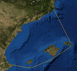
| Opis |
Català: Foto satèl·lit de la Mar Balear, delineada
Español: Foto satelital del Mar Balear
English: Satellite Picture of the Balearic Sea, delineated |
|||
| Datum | ||||
| Izvor | Satellite picture from NASA World Wind Globe, version 1.4; lines my work, based on definition at Limits of Oceans and Seas, 3rd edition by International Hydrographic Organisation. | |||
| Autor | NASA, Rwxrwxrwx | |||
| Dopuštenje (Naknadno korištenje ove datoteke) |
|

Historija datoteke
Kliknite na datum/vrijeme da vidite verziju datoteke iz tog vremena.
| Datum/vrijeme | Smanjeni pregled | Dimenzije | Korisnik | Komentar | |
|---|---|---|---|---|---|
| trenutno | 22:50, 30 septembar 2014 | | 1.060 × 989 (203 KB) | Rwxrwxrwx | User created page with UploadWizard |
Upotreba datoteke
Sljedeća stranica koristi ovu datoteku:
Globalna upotreba datoteke
Sljedeći wikiji koriste ovu datoteku:
- Upotreba na bn.wikipedia.org
- Upotreba na ca.wikipedia.org
- Upotreba na co.wikipedia.org
- Upotreba na da.wikipedia.org
- Upotreba na de.wikipedia.org
- Upotreba na en.wikipedia.org
- Upotreba na es.wikipedia.org
- Upotreba na eu.wikipedia.org
- Upotreba na fr.wikipedia.org
- Upotreba na gl.wikipedia.org
- Upotreba na he.wikipedia.org
- Upotreba na hr.wikipedia.org
- Upotreba na ilo.wikipedia.org
- Upotreba na it.wikipedia.org
- Upotreba na ja.wikipedia.org
- Upotreba na nl.wikipedia.org
- Upotreba na pl.wiktionary.org
- Upotreba na uk.wikipedia.org