Datoteka:Map of fertile cresent-sr.svg

Veličina ovog PNG pregleda za ovu SVG datoteku: 488 × 600 piksela. Ostale rezolucije: 195 × 240 piksela | 391 × 480 piksela | 625 × 768 piksela | 833 × 1.024 piksela | 1.667 × 2.048 piksela | 1.987 × 2.441 piksela.
Izvorna datoteka (SVG datoteka, nominalno 1.987 × 2.441 piksela, veličina datoteke: 467 KB)
| Ova datoteka je s Wikimedia Commonsa. Opis s njene stranice opisa datoteke prikazan je ispod. Commons je skladište slobodnih medija i datoteka za sve projekte fondacije Wikimedia. Možete i Vi pomoći. |
| Opis |
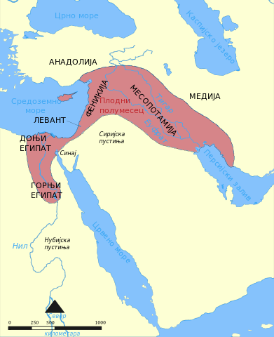
English: This map shows the location and extent of the Fertile Crescent, a region in the Middle East incorporating Ancient Egypt; the Levant; and Mesopotamia |
||
| Datum | (UTC) | ||
| Izvor | Map of fertile cresent.svg | ||
| Autor |
|
||
| SVG genesis | This map was created with Adobe Illustrator.
|
Ova datoteka je licencirana pod Creative Commons Attribution-Share Alike 3.0 neportiranom licencom.
- Slobodni ste:
- da dijelite – da kopirate, distributirate i prenosite djelo
- da remiksate – da prilagodite djelo
- Pod sljedećim uslovima:
- pripisivanje – Morate pripisati odgovarajuće autorske zasluge, osigurati link ka licenci i naznačiti jesu li napravljene izmjene. To možete uraditi na bilo koji razumni način, ali ne tako da se sugerira da davalac licence odobrava Vas ili Vašu upotrebu njegovog djela.
- dijeli pod istim uslovima – Ako mijenjate, transformišete ili nadograđujete ovaj materijal, morate ga objaviti i distribuirati samo pod istom ili sličnom licencom poput ove.
Originalni zapisnik postavljanja
This image is a derivative work of the following images:
- Map of fertile cresent.svg licensed with Cc-by-sa-3.0,2.5,2.0,1.0, GFDL
- 2011-05-22T11:06:47Z Nafsadh 1987x2441 (746245 Bytes) previous upload gurbled
- 2011-05-22T11:04:30Z Nafsadh 1987x2441 (746245 Bytes) Fonts enlarged
- 2011-05-22T10:53:48Z Nafsadh 1987x2441 (744760 Bytes) Fonts embedded
- 2011-05-22T10:45:20Z Nafsadh 1987x2441 (459645 Bytes) added region borders
- 2011-05-22T10:37:59Z Nafsadh 1987x2441 (186126 Bytes) {{Information |Description ={{en|1=This map shows the location and extent of the Fertile Crescent, a region in the Middle East incorporating Ancient Egypt; the Levant; and Mesopotamia}} |Source =Map_of_fertile_cres
Uploaded with derivativeFX
Historija datoteke
Kliknite na datum/vrijeme da vidite verziju datoteke iz tog vremena.
| Datum/vrijeme | Smanjeni pregled | Dimenzije | Korisnik | Komentar | |
|---|---|---|---|---|---|
| trenutno | 11:06, 14 septembar 2011 | | 1.987 × 2.441 (467 KB) | BokicaK | поцрнео нешто |
| 11:01, 14 septembar 2011 |  | 1.987 × 2.441 (467 KB) | BokicaK | flowed converted to text | |
| 04:40, 10 septembar 2011 |  | 1.987 × 2.441 (467 KB) | BokicaK | {{Information |Description={{en|1=This map shows the location and extent of the Fertile Crescent, a region in the Middle East incorporating Ancient Egypt; the Levant; and Mesopotamia}} |Source=*File:Map_of_fertile_cresent.svg |Date=2011-09-10 02:39 |
Upotreba datoteke
Sljedeća stranica koristi ovu datoteku:
Globalna upotreba datoteke
Sljedeći wikiji koriste ovu datoteku:
- Upotreba na sh.wikipedia.org
- Upotreba na sr.wikipedia.org