Datoteka:Main-Donau-Kanal-Karte.jpg

Veličina ovog prikaza: 702 × 600 piksela. Ostale rezolucije: 281 × 240 piksela | 562 × 480 piksela | 899 × 768 piksela | 1.198 × 1.024 piksela | 1.280 × 1.094 piksela.
Izvorna datoteka (1.280 × 1.094 piksela, veličina datoteke: 202 KB, MIME tip: image/jpeg)
| Ova datoteka je s Wikimedia Commonsa. Opis s njene stranice opisa datoteke prikazan je ispod. Commons je skladište slobodnih medija i datoteka za sve projekte fondacije Wikimedia. Možete i Vi pomoći. |

|
This map image could be re-created using vector graphics as an SVG file. This has several advantages; see Commons:Media for cleanup for more information. If an SVG form of this image is available, please upload it and afterwards replace this template with
{{vector version available|new image name}}.
It is recommended to name the SVG file “Main-Donau-Kanal-Karte.svg”—then the template Vector version available (or Vva) does not need the new image name parameter. |


| Opis |
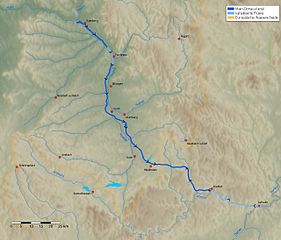
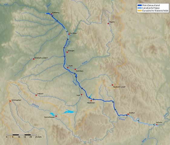
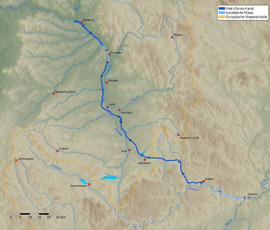
Deutsch: Karte des Main-Donau-Kanals zwischen Main (Bamberg) und Donau (Kelheim).
English: Map of the Rhine-Main-Danube Canal. |
| Datum | |
| Izvor | Own work. The background was generated by the Generic Mapping Tools (GMT, http://gmt.soest.hawaii.edu) using the public domain data of the GLOBE project (http://www.ngdc.noaa.gov/mgg/topo/gltiles.html). |
| Autor | jailbird |
Ova datoteka je licencirana pod Creative Commons licencom Attribution-Share Alike 2.0 Njemačka.
- Slobodni ste:
- da dijelite – da kopirate, distributirate i prenosite djelo
- da remiksate – da prilagodite djelo
- Pod sljedećim uslovima:
- pripisivanje – Morate pripisati odgovarajuće autorske zasluge, osigurati link ka licenci i naznačiti jesu li napravljene izmjene. To možete uraditi na bilo koji razumni način, ali ne tako da se sugerira da davalac licence odobrava Vas ili Vašu upotrebu njegovog djela.
- dijeli pod istim uslovima – Ako mijenjate, transformišete ili nadograđujete ovaj materijal, morate ga objaviti i distribuirati samo pod istom ili sličnom licencom poput ove.

Historija datoteke
Kliknite na datum/vrijeme da vidite verziju datoteke iz tog vremena.
| Datum/vrijeme | Smanjeni pregled | Dimenzije | Korisnik | Komentar | |
|---|---|---|---|---|---|
| trenutno | 20:53, 18 juni 2009 | | 1.280 × 1.094 (202 KB) | Jailbird | Maßstabsleiste hinzugefügt |
| 15:47, 22 januar 2007 |  | 1.280 × 1.094 (200 KB) | Jailbird | *Karte des Main-Donau-Kanals zwischen Main (Bamberg) und Donau (Kelheim). Das Bild wurde von mir am 19.1.2007 selbst erstellt. Das Hintergrundbild wurde mit den Generic Mapping Tools (GMT, http://gmt.soest.hawaii.edu) unter Verwen |
Upotreba datoteke
Sljedeća stranica koristi ovu datoteku:
Globalna upotreba datoteke
Sljedeći wikiji koriste ovu datoteku:
- Upotreba na bg.wikipedia.org
- Upotreba na cs.wikipedia.org
- Upotreba na da.wikipedia.org
- Upotreba na de.wikipedia.org
- Upotreba na de.wikisource.org
- Upotreba na de.wikiversity.org
- Upotreba na el.wikipedia.org
- Upotreba na en.wikipedia.org
- Upotreba na eo.wikipedia.org
- Upotreba na es.wikipedia.org
- Upotreba na et.wikipedia.org
- Upotreba na fi.wikipedia.org
- Upotreba na he.wikipedia.org
- Upotreba na hr.wikipedia.org
- Upotreba na hu.wikipedia.org
- Upotreba na id.wikipedia.org
- Upotreba na ja.wikipedia.org
- Upotreba na jv.wikipedia.org
- Upotreba na ko.wikipedia.org
- Upotreba na lo.wikipedia.org
- Upotreba na lt.wikipedia.org
- Upotreba na ms.wikipedia.org
- Upotreba na nl.wikipedia.org
- Upotreba na pt.wikipedia.org
- Upotreba na ru.wikipedia.org
- Upotreba na sh.wikipedia.org
- Upotreba na sk.wikipedia.org
- Upotreba na sl.wikipedia.org
- Upotreba na sv.wikipedia.org
- Upotreba na uk.wikipedia.org
- Upotreba na www.wikidata.org
- Upotreba na zh.wikipedia.org