Datoteka:Madagascar topo.jpg
Veća rezolucija nije dostupna.
Madagascar_topo.jpg (540 × 540 piksela, veličina datoteke: 94 KB, MIME tip: image/jpeg)
| Ova datoteka je s Wikimedia Commonsa. Opis s njene stranice opisa datoteke prikazan je ispod. Commons je skladište slobodnih medija i datoteka za sve projekte fondacije Wikimedia. Možete i Vi pomoći. |
Sažetak
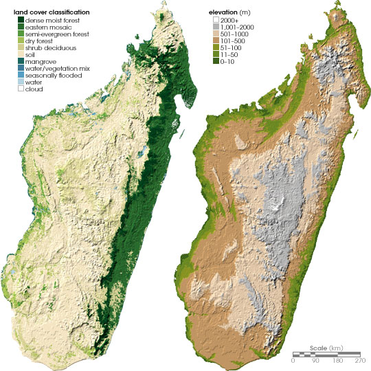
| Opis | Left: Land cover map of Madagascar. Right: Topographical map of Madagascar. |
| Datum | June 24, 2004 (published) |
| Izvor | http://earthobservatory.nasa.gov/Study/Chameleons/chameleons2.html Archived from the original on May 16, 2008 |
| Autor | Robert Simmon, based on data provided by Ned Horning, American Museum of Natural History (left), and Socioeconomic Data and Applications Center, Columbia University (right) |
| Dopuštenje (Naknadno korištenje ove datoteke) |
NASA, public domain |
| Ostale verzije | العربيَّة |
Licenciranje
| This file is in the public domain in the United States because it was solely created by NASA. NASA copyright policy states that "NASA material is not protected by copyright unless noted". (See Template:PD-USGov, NASA copyright policy page or JPL Image Use Policy.) | ||
 |
Warnings:
|
Historija datoteke
Kliknite na datum/vrijeme da vidite verziju datoteke iz tog vremena.
| Datum/vrijeme | Smanjeni pregled | Dimenzije | Korisnik | Komentar | |
|---|---|---|---|---|---|
| trenutno | 20:29, 25 maj 2006 | | 540 × 540 (94 KB) | Holly Cheng | {{Information | Description=Left: Land cover map of Madagascar. Right: Topographical map of Madagascar. | Source=http://earthobservatory.nasa.gov/Study/Chameleons/chameleons2.html | Date=June 24, 2004 (published) | Author=Robert Simmon, based on data prov |
Upotreba datoteke
Sljedeća stranica koristi ovu datoteku:
Globalna upotreba datoteke
Sljedeći wikiji koriste ovu datoteku:
- Upotreba na ar.wikipedia.org
- Upotreba na ca.wikipedia.org
- Upotreba na da.wikipedia.org
- Upotreba na de.wikipedia.org
- Upotreba na en.wikipedia.org
- Upotreba na es.wikipedia.org
- Upotreba na fa.wikipedia.org
- Upotreba na fr.wikipedia.org
- Upotreba na hr.wiktionary.org
- Upotreba na it.wikipedia.org
- Upotreba na ka.wikipedia.org
- Upotreba na ky.wikipedia.org
- Upotreba na nl.wikipedia.org
- Upotreba na no.wikipedia.org
- Upotreba na pnb.wikipedia.org
- Upotreba na pt.wikipedia.org
- Upotreba na ro.wikipedia.org
- Upotreba na ru.wikipedia.org
- Upotreba na si.wikipedia.org
- Upotreba na sl.wikipedia.org
- Upotreba na sr.wikipedia.org
- Upotreba na uk.wikipedia.org
- Upotreba na ur.wikipedia.org
- Upotreba na vec.wikipedia.org
- Upotreba na www.wikidata.org