Datoteka:Madaba map.jpg

Veličina ovog prikaza: 800 × 561 piksela. Ostale rezolucije: 320 × 224 piksela | 640 × 449 piksela | 1.024 × 718 piksela.
Izvorna datoteka (1.024 × 718 piksela, veličina datoteke: 193 KB, MIME tip: image/jpeg)
| Ova datoteka je s Wikimedia Commonsa. Opis s njene stranice opisa datoteke prikazan je ispod. Commons je skladište slobodnih medija i datoteka za sve projekte fondacije Wikimedia. Možete i Vi pomoći. |
Sažetak
| Opis |
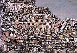
Deutsch: Darstellung Jerusalems auf der Mosaikkarte von Madaba
English: Jerusalem as seen on the Madaba Map
Español: Mosaico de Mandaba del siglo VI. Mosaico realizado circa 570 para decorar el suelo de una iglesia bizantina en Mandaba, Jordania. Muestra la región de Jordania y Palestina al norte y Egipto al sur, e incluye un plano de Jerusalén en el que se aprecia a la izquierda la puerta norte, de la que parte el Cardus Maximus en dirección sur. El mapa se encuentra en la iglesia ortodoxa de San Jorge, construída en 1896 sobre los restos de la Iglesia bizantina original, aunque solo se conserva un fragmento. Originalmente medía 25 x 5 metros. |
| Datum | |
| Izvor | W:en:Image:Madaba_map.jpg http://www.mcah.columbia.edu/dbcourses/islamic/large/madaba_map.jpg |
| Autor | Nepoznat |
|
This work is in the public domain in its country of origin and other countries and areas where the copyright term is the author's life plus 100 years or fewer. | |
| Ova datoteka je identificirana kao slobodna od poznatih ograničenja po zakonu o autorskim pravima, uključujući sva povezana i srodna prava. | |
Historija datoteke
Kliknite na datum/vrijeme da vidite verziju datoteke iz tog vremena.
| Datum/vrijeme | Smanjeni pregled | Dimenzije | Korisnik | Komentar | |
|---|---|---|---|---|---|
| trenutno | 15:28, 7 februar 2008 | | 1.024 × 718 (193 KB) | Gusgus | {{Information |Description=Madaba map, plano de Jerusalén del siglo VI. |Source=http://en.wikipedia.org/wiki/Image:Madaba_map.jpg |Date=7 de febrero de 2008 |Author=User:Gusgus |other_versions= }} {{PD-old}} Category:Ancient Roman forts |
Upotreba datoteke
Sljedeća stranica koristi ovu datoteku:
Globalna upotreba datoteke
Sljedeći wikiji koriste ovu datoteku:
- Upotreba na ar.wikipedia.org
- Upotreba na az.wikipedia.org
- Upotreba na be.wikipedia.org
- Upotreba na bg.wikipedia.org
- Upotreba na ca.wikipedia.org
- Upotreba na cs.wikipedia.org
- Upotreba na de.wikipedia.org
- Upotreba na de.wikiquote.org
- Upotreba na el.wikipedia.org
- Upotreba na en.wikipedia.org
- Aelia Capitolina
- Jerusalem
- Mosaic
- Timeline of Jerusalem
- History of Jerusalem
- Around the World in 80 Treasures
- Madaba Map
- Portal:Jordan
- Tourism in Jordan
- Early Byzantine mosaics in the Middle East
- Timeline of the Palestine region
- Gerasimus I of Jerusalem
- Cartography of Jerusalem
- Tel Hadid
- Draft:Outline of Jerusalem
- Upotreba na en.wikivoyage.org
- Upotreba na eo.wikipedia.org
- Upotreba na es.wikipedia.org
Pogledajte globalne upotrebe ove datoteke.