Datoteka:Lion distribution.png
Veličina ovog prikaza: 687 × 600 piksela. Ostale rezolucije: 275 × 240 piksela | 550 × 480 piksela | 880 × 768 piksela.
Izvorna datoteka (880 × 768 piksela, veličina datoteke: 51 KB, MIME tip: image/png)
| Ova datoteka je s Wikimedia Commonsa. Opis s njene stranice opisa datoteke prikazan je ispod. Commons je skladište slobodnih medija i datoteka za sve projekte fondacije Wikimedia. Možete i Vi pomoći. |

|
This map image could be re-created using vector graphics as an SVG file. This has several advantages; see Commons:Media for cleanup for more information. If an SVG form of this image is available, please upload it and afterwards replace this template with
{{vector version available|new image name}}.
It is recommended to name the SVG file “Lion distribution.svg”—then the template Vector version available (or Vva) does not need the new image name parameter. |
Sažetak
| Opis |
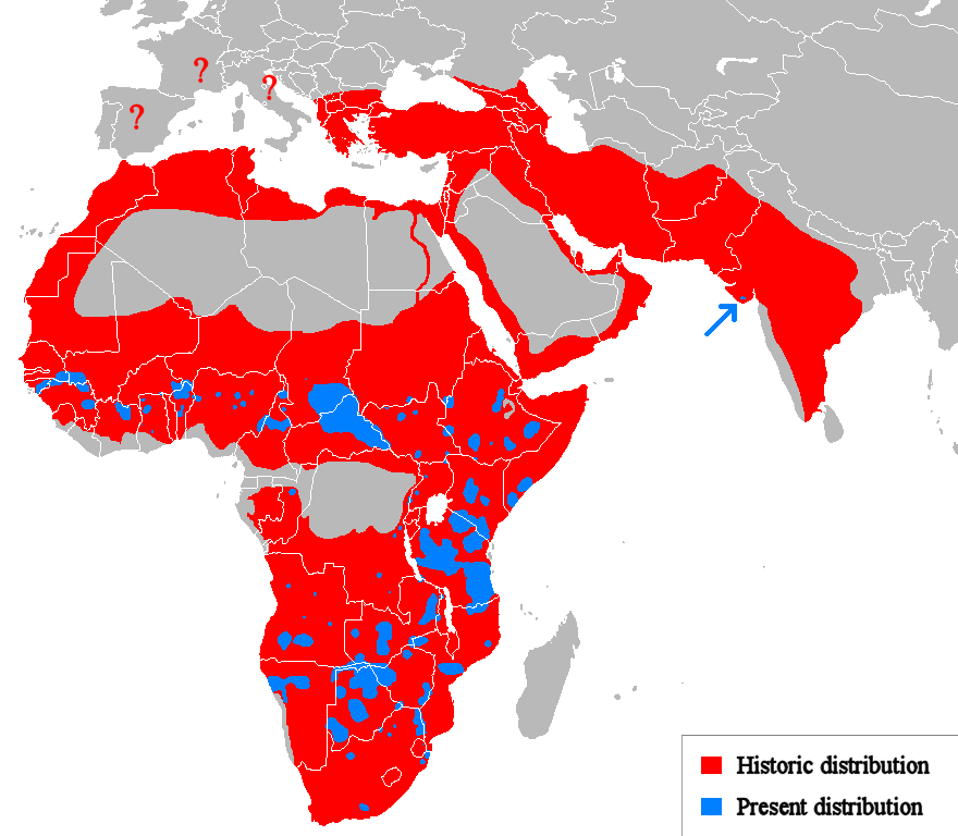
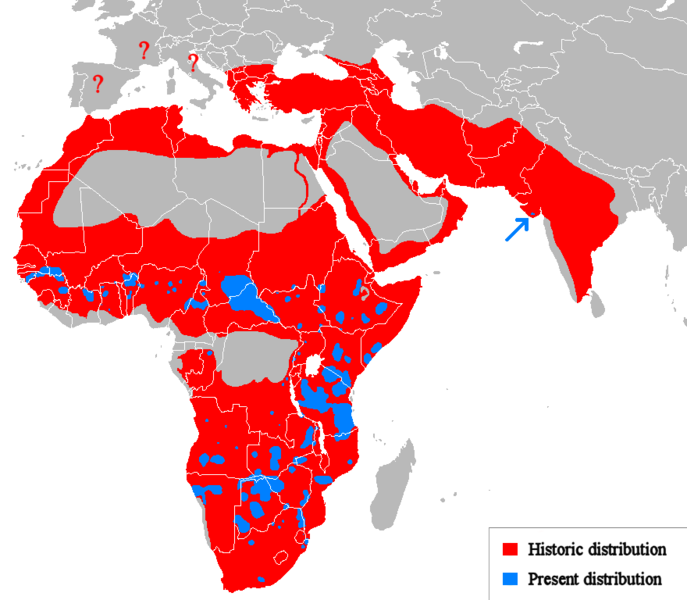
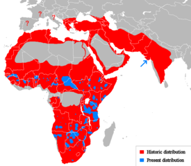
Euskara: Lehoien banaketa: Berdez gaur egun, gorriz historikoki.
Suomi: Leijonan levinneisyys vanhalla ajalla.
English: Geographical distribution of lions. Red (and blue) shows areas historically inhabited, blue shows areas currently inhabited.
Italiano: Areale storico (in rosso) ed attuale (in blu).
Русский: Ареал льва |
| Datum | (UTC) |
| Izvor |
Own work using:
|
| Autor | Tommyknocker (talk) |
| Ostale verzije | Derivative works of this file: Lion distribution-ar.png |
Licenciranje
| Ovaj rad je objavljen u javno vlasništvo od strane autora Tommyknocker at engleski Wikipedia. Ovo se primjenjuje širom svijeta. U nekim državama ovo zakonski nije moguće; u tom slučaju: Tommyknocker dopušta svima pravo korištenja ovog rada u bilo koju svrhu, bez ikakvih uslova, osim ako su takvi uslovi zakonski neophodni. |
Originalni zapisnik postavljanja
Transferred from en.wikipedia to Commons by Egmontaz using CommonsHelper.
The original description page was here. All following user names refer to en.wikipedia.
- 2009-08-26 11:21 Tommyknocker 882×770× (42518 bytes) '
- 2009-08-24 21:02 Tommyknocker 882×770× (42434 bytes) {{Information |Description = |Source = I (~~~) created this work entirely by myself. |Date = ~~~~~ |Author = ~~~ |other_versions = }}
Historija datoteke
Kliknite na datum/vrijeme da vidite verziju datoteke iz tog vremena.
| Datum/vrijeme | Smanjeni pregled | Dimenzije | Korisnik | Komentar | |
|---|---|---|---|---|---|
| trenutno | 13:51, 22 mart 2018 | | 880 × 768 (51 KB) | Maphobbyist | Check |
| 13:23, 22 mart 2018 |  | 880 × 768 (51 KB) | Maphobbyist | South Sudan border | |
| 03:07, 15 maj 2012 |  | 880 × 768 (33 KB) | Ras67 | cropped, optimized | |
| 16:06, 19 april 2010 |  | 882 × 770 (59 KB) | MPF | Change red/green to red/blue to avoid problems for viewers with red-green colourblindness | |
| 22:00, 11 januar 2010 |  | 882 × 770 (44 KB) | Tommyknocker | Distribution in Southern Europe during historical times controversial, therefore now represented with question marks. | |
| 19:01, 2 novembar 2009 |  | 882 × 770 (42 KB) | File Upload Bot (Magnus Manske) | {{BotMoveToCommons|en.wikipedia|year={{subst:CURRENTYEAR}}|month={{subst:CURRENTMONTHNAME}}|day={{subst:CURRENTDAY}}}} {{Information |Description={{en|''no original description''}} |Source=Transferred from [http://en.wikipedia.org en.wikipedia]; transfer |
Upotreba datoteke
Sljedeća stranica koristi ovu datoteku:
Globalna upotreba datoteke
Sljedeći wikiji koriste ovu datoteku:
- Upotreba na ab.wikipedia.org
- Upotreba na af.wikipedia.org
- Upotreba na alt.wikipedia.org
- Upotreba na am.wikipedia.org
- Upotreba na ary.wikipedia.org
- Upotreba na arz.wikipedia.org
- Upotreba na ast.wikipedia.org
- Upotreba na as.wikipedia.org
- Upotreba na azb.wikipedia.org
- Upotreba na ban.wikipedia.org
- Upotreba na ba.wikipedia.org
- Upotreba na bcl.wikipedia.org
- Upotreba na be.wikipedia.org
- Upotreba na bg.wikipedia.org
- Upotreba na bh.wikipedia.org
- Upotreba na bn.wikipedia.org
- Upotreba na ca.wikipedia.org
- Upotreba na ca.wikiquote.org
- Upotreba na ceb.wikipedia.org
- Upotreba na ce.wikipedia.org
- Upotreba na ckb.wikipedia.org
- Upotreba na cs.wikipedia.org
- Upotreba na de.wikipedia.org
- Upotreba na de.wikibooks.org
- Upotreba na diq.wikipedia.org
- Upotreba na el.wikipedia.org
- Upotreba na en.wikipedia.org
- Upotreba na eo.wikipedia.org
- Upotreba na eo.wiktionary.org
- Upotreba na es.wikipedia.org
- Upotreba na es.wikibooks.org
- Upotreba na et.wikipedia.org
- Upotreba na eu.wikipedia.org
- Upotreba na ext.wikipedia.org
Pogledajte globalne upotrebe ove datoteke.