Datoteka:Karte Aut Ooe SE.png
Veća rezolucija nije dostupna.
Karte_Aut_Ooe_SE.png (300 × 265 piksela, veličina datoteke: 4 KB, MIME tip: image/png)
| Ova datoteka je s Wikimedia Commonsa. Opis s njene stranice opisa datoteke prikazan je ispod. Commons je skladište slobodnih medija i datoteka za sve projekte fondacije Wikimedia. Možete i Vi pomoći. |
Sažetak
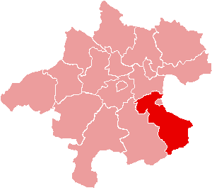
| Opis | Location of Bezirk Steyr-Land within the Land of Upper Austria |
| Datum | |
| Izvor | de:Bild:Karte Aut Ooe SE.png |
| Autor | de:Benutzer:Plp |
| Dopuštenje (Naknadno korištenje ove datoteke) |
GFDL-author (licence from German Wikipedia) |
| Ostale verzije | de:Bild:Karte Aut Ooe SE.png |
Licenciranje

|
Dozvoljeno je kopirati, distribuirati i/ili mijenjati ovaj članak pod uslovima navedenim u GNU licenci za slobodnu dokumentaciju, verzija 1.2 ili kasnijom verzijom izdatom od Free Software Foundation; bez nepromjenljivih dijelova, te bez sadržaja na naslovnoj i zadnjoj strani. Kopija licence se nalazi pod poglavljem GNU Free Documentation License. |
| Ova datoteka je licencirana pod Creative Commons Attribution-Share Alike 3.0 neportiranom licencom. | ||
| ||
| Ova oznaka licence je dodana na ovu datoteku kao dio GFDL ažuriranja licence. |
Historija datoteke
Kliknite na datum/vrijeme da vidite verziju datoteke iz tog vremena.
| Datum/vrijeme | Smanjeni pregled | Dimenzije | Korisnik | Komentar | |
|---|---|---|---|---|---|
| trenutno | 17:17, 23 juni 2006 | | 300 × 265 (4 KB) | Physchim62 | {{Information |Description=Location of Bezirk Steyr-Land within the Land of Upper Austria |Source=de:Bild:Karte Aut Ooe SE.png |Date=2004 |Author=de:Benutzer:Plp |Permission=GFDL-autho |
Upotreba datoteke
Sljedeća stranica koristi ovu datoteku:
Globalna upotreba datoteke
Sljedeći wikiji koriste ovu datoteku:
- Upotreba na ce.wikipedia.org
- Upotreba na cs.wikipedia.org
- Upotreba na de.wikipedia.org
- Upotreba na es.wikipedia.org
- Upotreba na fa.wikipedia.org
- Upotreba na fr.wikipedia.org
- District de Steyr-Land
- Gaflenz
- Modèle:Palette District de Steyr-Land
- Adlwang
- Aschach an der Steyr
- Bad Hall
- Dietach
- Garsten
- Laussa
- Losenstein
- Maria Neustift
- Pfarrkirchen bei Bad Hall
- Reichraming
- Großraming
- Rohr im Kremstal
- Schiedlberg
- Sierning
- Sankt Ulrich bei Steyr
- Ternberg
- Waldneukirchen
- Wolfern
- Weyer (Autriche)
- Upotreba na fur.wikipedia.org
- Upotreba na he.wikipedia.org
- Upotreba na hu.wikipedia.org
Pogledajte globalne upotrebe ove datoteke.