Datoteka:Java map.png
Java_map.png (500 × 338 piksela, veličina datoteke: 30 KB, MIME tip: image/png)
| Ova datoteka je s Wikimedia Commonsa. Opis s njene stranice opisa datoteke prikazan je ispod. Commons je skladište slobodnih medija i datoteka za sve projekte fondacije Wikimedia. Možete i Vi pomoći. |
This image was copied from wikipedia:en. The original description was:
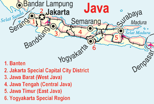
Adapted from http://www.un.org/Depts/Cartographic/map/profile/indonesi.pdf
| This image is a map derived from a United Nations map.
Unless stated otherwise, UN maps are to be considered in the public domain. This applies worldwide. UN maps are, in principle, open source material and you can use them in your work or for making your own map. UN requests however that you delete the UN name, logo and reference number upon any modification to the map. Content of your map will be your responsibility. You can state in your publication, if you wish, something like: based on UN map … (map name, map number, revision number and date). See: Geospatial Information Section. And: Geospatial, location data for a better world. |
 |
| date/time | username | edit summary |
|---|---|---|
| 14:24, 20 May 2005 | ChrisO | ({{UN map}}) |
| 13:53, 20 May 2005 | ChrisO | (+<a href="/wiki/Category:United_Nations_mapping" title="Category:United Nations mapping">Category:United Nations mapping</a>) |
| 21:39, 28 April 2005 | ChrisO | (Map of <a href="/wiki/Java_%28island%29" title="Java (island)">Java</a>, <a href="/wiki/Indonesia" title="Indonesia">Indonesia</a> Adapted from http://www.un.org/Depts/Cartographic/map/profile/indonesi.pdf {{PD}}) |
Historija datoteke
Kliknite na datum/vrijeme da vidite verziju datoteke iz tog vremena.
| Datum/vrijeme | Smanjeni pregled | Dimenzije | Korisnik | Komentar | |
|---|---|---|---|---|---|
| trenutno | 14:55, 5 oktobar 2005 | | 500 × 338 (30 KB) | ChongDae | This image was copied from wikipedia:en. The original description was: Map of Java, Indonesia Adapted from http://www.un.org/Depts/Cartographic/map/profile/indonesi.pdf {{UN map}} Category:United Nations mapping {| border="1 |
Upotreba datoteke
Sljedeća stranica koristi ovu datoteku:
Globalna upotreba datoteke
Sljedeći wikiji koriste ovu datoteku:
- Upotreba na bn.wikipedia.org
- Upotreba na ca.wikipedia.org
- Upotreba na cs.wikipedia.org
- Upotreba na de.wikipedia.org
- Upotreba na de.wiktionary.org
- Upotreba na fa.wikipedia.org
- Upotreba na fi.wikipedia.org
- Upotreba na hr.wikipedia.org
- Upotreba na ja.wikipedia.org
- Upotreba na kk.wikipedia.org
- Upotreba na ko.wikipedia.org
- Upotreba na lb.wikipedia.org
- Upotreba na no.wikipedia.org
- Upotreba na pl.wikinews.org
- Upotreba na ps.wikipedia.org
- Upotreba na ro.wikipedia.org
- Upotreba na scn.wikipedia.org
- Upotreba na sh.wikipedia.org
- Upotreba na sw.wikipedia.org
- Upotreba na ta.wiktionary.org