Datoteka:Indo-Greeks 100bc.jpg
Izvorna datoteka (880 × 659 piksela, veličina datoteke: 696 KB, MIME tip: image/jpeg)
| Ova datoteka je s Wikimedia Commonsa. Opis s njene stranice opisa datoteke prikazan je ispod. Commons je skladište slobodnih medija i datoteka za sve projekte fondacije Wikimedia. Možete i Vi pomoći. |

|
This historical map image could be re-created using vector graphics as an SVG file. This has several advantages; see Commons:Media for cleanup for more information. If an SVG form of this image is available, please upload it and afterwards replace this template with
{{vector version available|new image name}}.
It is recommended to name the SVG file “Indo-Greeks 100bc.svg”—then the template Vector version available (or Vva) does not need the new image name parameter. |


Sažetak
| Opis |
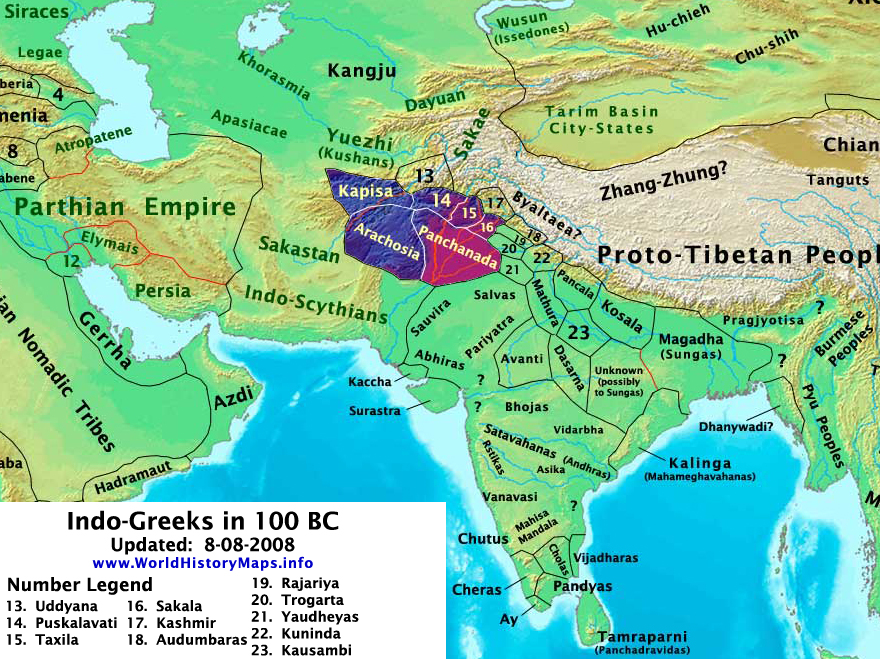
English: The Indo-Greek Kingdoms in 100 BC.. |
| Datum | |
| Izvor | Vlastito djelo |
| Autor | Thomas Lessman • (Contact!) |
| Dopuštenje (Naknadno korištenje ove datoteke) |
Ja, vlasnik autorskog prava ovog djela, ovdje ga objavljujem pod sljedećom licencom: Ova datoteka je licencirana pod Creative Commons Attribution-Share Alike 3.0 neportiranom licencom.
|
| Ostale verzije | see below |
Map Summary

Original Source URL: http://www.thomaslessman.com/History/images/East-Hem_100bc.jpg
This map is a zoomed-in version of Thomas Lessman's map of the East Hemisphere in 100 BC, also available at www.WorldHistoryMaps.info.
Highlighted areas represent lands of the Indo-Greek Kingdoms in 100 BC, (after the fall of Greco-Bactria and on the eve of the Indo-Scythian invasion of India. Note: Source information is below.
Map Source References
Remember, sources often conflict with each other. This map is only as accurate as the information that is available to me. To report any errors or to help further this work, please click here, or email Thomas Lessman at talessman@yis.us
References for information contained in this map:
- *See the references for East-Hem_100bc.jpg
Other Maps by Thomas Lessman
| Maps of the eastern hemisphere showing history
Bold dates are available on Wikimedia or Wikipedia. | ||
| Primeval | ||
| Ancient
|
·| 600 BC | 550 BC | 527 BC | 500 BC |
400 BC | ·| 1 AD | 50 AD | 100 AD | 200 AD | 300 AD | | |
| Medieval |
·| 500 AD | 565 AD | 600 AD | 700 AD | | |
| Modern |
·| 1500 AD | · * For historical maps of the whole world, | |
Other Info
Licenciranje
- Slobodni ste:
- da dijelite – da kopirate, distributirate i prenosite djelo
- da remiksate – da prilagodite djelo
- Pod sljedećim uslovima:
- pripisivanje – Morate pripisati odgovarajuće autorske zasluge, osigurati link ka licenci i naznačiti jesu li napravljene izmjene. To možete uraditi na bilo koji razumni način, ali ne tako da se sugerira da davalac licence odobrava Vas ili Vašu upotrebu njegovog djela.
- dijeli pod istim uslovima – Ako mijenjate, transformišete ili nadograđujete ovaj materijal, morate ga objaviti i distribuirati samo pod istom ili sličnom licencom poput ove.
Historija datoteke
Kliknite na datum/vrijeme da vidite verziju datoteke iz tog vremena.
| Datum/vrijeme | Smanjeni pregled | Dimenzije | Korisnik | Komentar | |
|---|---|---|---|---|---|
| trenutno | 18:42, 9 august 2008 | | 880 × 659 (696 KB) | Talessman | Updates to various borders and surrounding cultures/peoples. |
| 01:13, 2 august 2008 |  | 790 × 736 (738 KB) | Talessman | {{Information |Description= |Source= |Date= |Author= |Permission= |other_versions= }} | |
| 21:32, 30 juli 2008 |  | 818 × 620 (458 KB) | Talessman | {{Information |Description={{en|1=Indo-Greek Kingdoms in 100 BC.}} |Source=Own work by uploader |Author=Talessman |Date=5-16-2008 |Permission= |other_versions= }} {{ImageUpload|full}} |
Upotreba datoteke
Sljedeća stranica koristi ovu datoteku:
Globalna upotreba datoteke
Sljedeći wikiji koriste ovu datoteku:
- Upotreba na ar.wikipedia.org
- Upotreba na bg.wikipedia.org
- Upotreba na bn.wikipedia.org
- Upotreba na cs.wikipedia.org
- Upotreba na cv.wikipedia.org
- Upotreba na en.wikipedia.org
- Upotreba na es.wikipedia.org
- Upotreba na eu.wikipedia.org
- Upotreba na fr.wikipedia.org
- Upotreba na hi.wikipedia.org
- Upotreba na hu.wikisource.org
- Upotreba na hy.wikipedia.org
- Upotreba na id.wikipedia.org
- Upotreba na it.wikipedia.org
- Upotreba na ko.wikipedia.org
- Upotreba na ml.wikipedia.org
- Upotreba na ms.wikipedia.org
- Upotreba na nn.wikipedia.org
- Upotreba na no.wikipedia.org
- Upotreba na pa.wikipedia.org
- Upotreba na pl.wikipedia.org
- Upotreba na pnb.wikipedia.org
- Upotreba na pt.wikipedia.org
- Upotreba na ru.wikipedia.org
- Upotreba na sh.wikipedia.org
- Upotreba na simple.wikipedia.org
- Upotreba na si.wikipedia.org
- Upotreba na sr.wikipedia.org
- Upotreba na sv.wikipedia.org
- Upotreba na uk.wikipedia.org
- Upotreba na ur.wikipedia.org
- Upotreba na zh.wikipedia.org