Datoteka:Great Schism 1054 with former borders.png

Veličina ovog prikaza: 560 × 599 piksela. Ostale rezolucije: 224 × 240 piksela | 448 × 480 piksela | 717 × 768 piksela | 957 × 1.024 piksela | 2.000 × 2.141 piksela.
Izvorna datoteka (2.000 × 2.141 piksela, veličina datoteke: 420 KB, MIME tip: image/png)
| Ova datoteka je s Wikimedia Commonsa. Opis s njene stranice opisa datoteke prikazan je ispod. Commons je skladište slobodnih medija i datoteka za sve projekte fondacije Wikimedia. Možete i Vi pomoći. |

|
This religion map image could be re-created using vector graphics as an SVG file. This has several advantages; see Commons:Media for cleanup for more information. If an SVG form of this image is available, please upload it and afterwards replace this template with
{{vector version available|new image name}}.
It is recommended to name the SVG file “Great Schism 1054 with former borders.svg”—then the template Vector version available (or Vva) does not need the new image name parameter. |
Sažetak
| Opis |
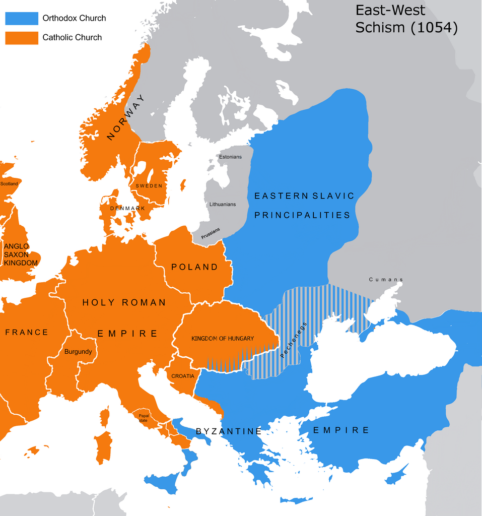
English: The map of the eastern/western allegiances in 1054 with the former country borders.
Español: El mapa de las creencias en el este/oeste en 1054 con las fronteras del país anterior. Los puntos representan concentraciones de minorías y no ubicaciones específicas. Las líneas rayadas representan cohabitaciones religiosas y no mayorías (que están representadas por colores sólidos).
Deutsch: Karte über das Morgenländische Schisma mit den ehemaligen Landesgrenzen. Die schraffierten Linien stellen religiöse Zusammenleben und keine Mehrheiten dar (die durch Vollfarben dargestellt werden).
Magyar: A nagy kelet-nyugati egyházszakadás térképe az 1054-nek megfelelő határokkal. A pontok a kisebbségek koncentrációját jelölik, nem pedig meghatározott helyeket. A sraffozott vonalak a vallási együttéléseket jelölik, nem pedig a többséget (amelyeket egyszínű színek jelölnek). |
||
| Datum | 04.09.2010. | ||
| Izvor | Source: Westermanns Atlas zur Weltgeschichte, 1957, p. 64-5, maps titled "Staaten u. Bekenntnisse im Mittelmeerraum nach den ersten Kreuzzügen (um 1190)" (p. 64) and "Mittelmeerwelt und Vorderasien vor Beginn der Kreuzzüge (1096)" (p. 65) and Alexander Kazhdan (dir.), Oxford Dictionary of Byzantium, Oxford University Press, 1991, 1re éd., 3 tom. (ISBN 978-0-19-504652-6, LCCN 90023208), art. « Patriarchates », vol. 3, pp. 1599-1600. | ||
| Autor | Tobi85 | ||
| Dopuštenje (Naknadno korištenje ove datoteke) |
|
||
| Ostale verzije | Derivative works of this file: Great Schism 1054 with former borders-ar.png |
Licenciranje
| Ja, vlasnik autorskog prava ovog djela, objavljujem ovaj rad u javno vlasništvo. Ovo se primjenjuje u cijelom svijetu. U nekim državama ovo zakonski nije moguće; u tom slučaju: Ja dopuštam svima pravo korištenja ovog rada u bilo koju svrhu, bez ikakvih uslova, osim ako su takvi uslovi zakonski neophodni. |
_en.png)
.png)
.jpg)
Historija datoteke
Kliknite na datum/vrijeme da vidite verziju datoteke iz tog vremena.
| Datum/vrijeme | Smanjeni pregled | Dimenzije | Korisnik | Komentar | |
|---|---|---|---|---|---|
| trenutno | 15:16, 9 juli 2023 | | 2.000 × 2.141 (420 KB) | Veverve | Reverted to version as of 21:25, 11 November 2022 (UTC): this is a huge extrapolation to make based solely on the fact that there were some Byzantine churches in Hungary |
| 17:01, 19 mart 2023 |  | 2.000 × 2.141 (439 KB) | Moodylo333 | Reverted to 8 November 2017 according with Dora Wiebenson, József Sisa, Pál Lövei, "The architecture of historic Hungary" (p. 11) who admit the presence of byzantine churches in Eastern Hungary. | |
| 23:25, 11 novembar 2022 |  | 2.000 × 2.141 (420 KB) | Gyalu22 | As Veverve said, no personal opinions should be used. The previous status in Hungary was drawn by Cepleanu who referred to the Westermanns Atlas in the talk page. But that atlas shows the situation very differently. | |
| 21:58, 23 oktobar 2022 |  | 2.000 × 2.141 (479 KB) | Veverve | Reverted to version as of 11:04, 1 June 2022 (UTC) original research and personnal opinions should no be used | |
| 21:12, 23 oktobar 2022 |  | 2.000 × 2.141 (492 KB) | Gyalu22 | Religion was not an ethnic question. Transylvania was a religiously diverse region, but Catholicism was already dominant to Alba Iulia | |
| 13:04, 1 juni 2022 |  | 2.000 × 2.141 (479 KB) | Moodylo333 | Reliable version with Alexander Kazhdan (dir.), Oxford Dictionary of Byzantium, New York et Oxford, Oxford University Press, 1991, 1re éd., 3 tom. (ISBN 978-0-19-504652-6 et 0-19-504652-8, LCCN 90023208), 1991, art. « Patriarchates », vol. 3, pp. 1599-1600. | |
| 15:51, 1 februar 2022 |  | 2.000 × 2.141 (488 KB) | Moodylo333 | Reverted to version as of 20:17, 8 July 2018 (UTC) without Bogomils (off topic) | |
| 15:49, 1 februar 2022 |  | 2.000 × 2.141 (488 KB) | Moodylo333 | Reverted to version as of 20:15, 8 July 2018 (UTC) : COM:CROP | |
| 11:41, 26 novembar 2021 |  | 2.000 × 2.141 (420 KB) | Veverve | Reverted to version as of 15:53, 26 October 2011 (UTC) revert to version closer to the Westermanns Atlas zur Weltgeschichte, see File_talk:Great_Schism_1054_with_former_borders.png#Numerous_problems,_map_is_unreliable | |
| 01:18, 30 maj 2021 |  | 2.000 × 2.141 (494 KB) | Ceha | Catholic-ortodox borders in the southeast |
Upotreba datoteke
Nema stranica koje koriste ovu datoteku.
Globalna upotreba datoteke
Sljedeći wikiji koriste ovu datoteku:
- Upotreba na ar.wikipedia.org
- Upotreba na ca.wikipedia.org
- Upotreba na cs.wikipedia.org
- Upotreba na de.wikipedia.org
- Upotreba na de.wikibooks.org
- Upotreba na en.wikipedia.org
- Upotreba na fr.wikipedia.org
- Upotreba na ga.wikipedia.org
- Upotreba na hu.wikipedia.org
- Upotreba na ro.wikipedia.org
- Upotreba na www.wikidata.org