Datoteka:GoldenHorde1300.png

Veličina ovog prikaza: 800 × 481 piksela. Ostale rezolucije: 320 × 193 piksela | 640 × 385 piksela | 1.024 × 616 piksela | 1.436 × 864 piksela.
Izvorna datoteka (1.436 × 864 piksela, veličina datoteke: 47 KB, MIME tip: image/png)
| Ova datoteka je s Wikimedia Commonsa. Opis s njene stranice opisa datoteke prikazan je ispod. Commons je skladište slobodnih medija i datoteka za sve projekte fondacije Wikimedia. Možete i Vi pomoći. |

|
This map image could be re-created using vector graphics as an SVG file. This has several advantages; see Commons:Media for cleanup for more information. If an SVG form of this image is available, please upload it and afterwards replace this template with
{{vector version available|new image name}}.
It is recommended to name the SVG file “GoldenHorde1300.svg”—then the template Vector version available (or Vva) does not need the new image name parameter. |
Sažetak
| Opis |
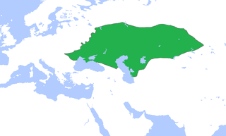
English: Locator map of the Golden Horde, c. 1300.
(Partially based on Atlas of World History (2007) - The World 1200-1300, map) |
| Datum | |
| Izvor | Vlastito djelo |
| Autor | Gabagool |
Licenciranje
Ja, vlasnik autorskog prava ovog djela, ovdje ga objavljujem pod sljedećom licencom:
Ova datoteka je licencirana pod Creative Commons Attribution 3.0 neportiranom licencom.
- Slobodni ste:
- da dijelite – da kopirate, distributirate i prenosite djelo
- da remiksate – da prilagodite djelo
- Pod sljedećim uslovima:
- pripisivanje – Morate pripisati odgovarajuće autorske zasluge, osigurati link ka licenci i naznačiti jesu li napravljene izmjene. To možete uraditi na bilo koji razumni način, ali ne tako da se sugerira da davalac licence odobrava Vas ili Vašu upotrebu njegovog djela.
Historija datoteke
Kliknite na datum/vrijeme da vidite verziju datoteke iz tog vremena.
| Datum/vrijeme | Smanjeni pregled | Dimenzije | Korisnik | Komentar | |
|---|---|---|---|---|---|
| trenutno | 17:58, 16 novembar 2022 | | 1.436 × 864 (47 KB) | Gyalu22 | Reverted to version as of 16:08, 5 June 2009 (UTC) |
| 18:12, 7 juni 2021 |  | 1.436 × 864 (28 KB) | Devlet Geray | Reverted to version as of 11:20, 4 June 2018 (UTC) they paid tribute to the Khan and because of this could trade but there were no independent states in Southern Crimea | |
| 14:04, 4 juni 2018 |  | 1.436 × 864 (28 KB) | Julieta39 | No Golden Horde control on the Southern Crimea (byzantine, later Theodoro principality) | |
| 13:20, 4 juni 2018 |  | 1.436 × 864 (28 KB) | Julieta39 | Shorelines, no modern dam lakes, Hungary and Galicia no ruled by Golden Horde | |
| 18:08, 5 juni 2009 |  | 1.436 × 864 (47 KB) | Gabagool | slightly cropped | |
| 15:00, 25 april 2009 |  | 1.644 × 959 (56 KB) | Gabagool | {{Information |Description={{en|1=Locator map of the Golden Horde, c. 1300. (Partially based on ''Atlas of World History'' (2007) - The World 1200-1300, map)}} |Source=Own work by uploader |Author=Gabagool / Jarle Grøhn |Date=2009-04-2 |
Upotreba datoteke
Sljedeća stranica koristi ovu datoteku:
Globalna upotreba datoteke
Sljedeći wikiji koriste ovu datoteku:
- Upotreba na af.wikipedia.org
- Upotreba na ar.wikipedia.org
- Upotreba na arz.wikipedia.org
- Upotreba na ast.wikipedia.org
- Upotreba na azb.wikipedia.org
- Upotreba na az.wikipedia.org
- Upotreba na be.wikipedia.org
- Upotreba na ca.wikipedia.org
- Upotreba na cs.wikipedia.org
- Upotreba na cv.wikipedia.org
- Upotreba na cy.wikipedia.org
- Upotreba na da.wikipedia.org
- Upotreba na el.wikipedia.org
- Upotreba na en.wikipedia.org
- Upotreba na eo.wikipedia.org
- Upotreba na es.wikipedia.org
- Upotreba na et.wikipedia.org
- Upotreba na eu.wikipedia.org
- Upotreba na fa.wikipedia.org
- Upotreba na fr.wikipedia.org
- Upotreba na ga.wikipedia.org
- Upotreba na gl.wikipedia.org
- Upotreba na hi.wikipedia.org
- Upotreba na hr.wikipedia.org
- Upotreba na hu.wikipedia.org
- Upotreba na hy.wikipedia.org
- Upotreba na id.wikipedia.org
- Upotreba na incubator.wikimedia.org
Pogledajte globalne upotrebe ove datoteke.