Datoteka:Golan 92.jpg

Veličina ovog prikaza: 475 × 599 piksela. Ostale rezolucije: 190 × 240 piksela | 380 × 480 piksela | 1.000 × 1.262 piksela.
Izvorna datoteka (1.000 × 1.262 piksela, veličina datoteke: 236 KB, MIME tip: image/jpeg)
| Ova datoteka je s Wikimedia Commonsa. Opis s njene stranice opisa datoteke prikazan je ispod. Commons je skladište slobodnih medija i datoteka za sve projekte fondacije Wikimedia. Možete i Vi pomoći. |
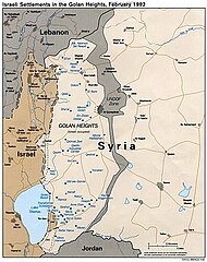
map of Golan Heights ; from w:Image:Golan_92.jpg ; CIA ; PD
Tulsa City County Library's record for the image has the following information: [1]
| Corp author | United States. Central Intelligence Agency. |
| Title | Israeli settlements in the Golan Heights, February 1992. |
| Published | Washington, D.C. : Central Intelligence Agency, 1992 |
| Map format | Scale [ca. 1:410,000] |
| Description | 1 map : col. ; 21 x 17 cm. |
| Note | "724711 (R00412) 4-92." |
User:Thuresson 06:57, 19 Feb 2005 (UTC)
This work is in the public domain in the United States because it is a work prepared by an officer or employee of the United States Government as part of that person’s official duties under the terms of Title 17, Chapter 1, Section 105 of the US Code.
Note: This only applies to original works of the Federal Government and not to the work of any individual U.S. state, territory, commonwealth, county, municipality, or any other subdivision. This template also does not apply to postage stamp designs published by the United States Postal Service since 1978. (See § 313.6(C)(1) of Compendium of U.S. Copyright Office Practices). It also does not apply to certain US coins; see The US Mint Terms of Use.
|
 | |
| Ova datoteka je identificirana kao slobodna od poznatih ograničenja po zakonu o autorskim pravima, uključujući sva povezana i srodna prava. | ||
Historija datoteke
Kliknite na datum/vrijeme da vidite verziju datoteke iz tog vremena.
| Datum/vrijeme | Smanjeni pregled | Dimenzije | Korisnik | Komentar | |
|---|---|---|---|---|---|
| trenutno | 15:40, 1 mart 2015 | | 1.000 × 1.262 (236 KB) | Danny lost | bigger |
| 15:04, 20 februar 2005 |  | 650 × 785 (91 KB) | Mats Halldin~commonswiki | map of Golan Heights ; from w:Image:Golan_92.jpg ; CIA ; PD {{PD}} |
Upotreba datoteke
Sljedeća stranica koristi ovu datoteku:
Globalna upotreba datoteke
Sljedeći wikiji koriste ovu datoteku:
- Upotreba na ar.wikipedia.org
- Upotreba na arz.wikipedia.org
- Upotreba na azb.wikipedia.org
- Upotreba na ca.wikipedia.org
- Upotreba na ckb.wikipedia.org
- Upotreba na cs.wikipedia.org
- Upotreba na cy.wikipedia.org
- Upotreba na da.wikipedia.org
- Upotreba na de.wikipedia.org
- Upotreba na de.wikinews.org
- Upotreba na en.wikipedia.org
- Israeli settlement
- User:John Z/drafts/Golan Heights
- Israeli-occupied territories
- United Nations Security Council Resolution 398
- United Nations Security Council Resolution 408
- United Nations Security Council Resolution 420
- User:Gimmetrow/test
- User:Gimmetrow/test2
- United Nations Security Council Resolution 679
- User:Bolter21/Userboxes/GolanHeighstIsrael
- User:Bolter21/Userboxes/GolanHeightsSyria
- User:Bolter21/Userboxes
- User:Falcaorib
- User:Carthago814
- Upotreba na eo.wikipedia.org
- Upotreba na es.wikipedia.org
- Upotreba na et.wikipedia.org
- Upotreba na eu.wikipedia.org
- Upotreba na fa.wikipedia.org
- Upotreba na fr.wikipedia.org
- Upotreba na fr.wikinews.org
- Upotreba na hr.wikipedia.org
- Upotreba na hu.wikipedia.org
- Upotreba na id.wikipedia.org
Pogledajte globalne upotrebe ove datoteke.