Datoteka:Central African Republic-CIA WFB Map.png
Veća rezolucija nije dostupna.
Central_African_Republic-CIA_WFB_Map.png (328 × 352 piksela, veličina datoteke: 49 KB, MIME tip: image/png)
| Ova datoteka je s Wikimedia Commonsa. Opis s njene stranice opisa datoteke prikazan je ispod. Commons je skladište slobodnih medija i datoteka za sve projekte fondacije Wikimedia. Možete i Vi pomoći. |
Sažetak
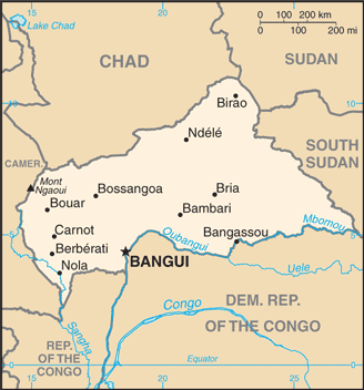
| Opis | Central African Republic map from CIA World Factbook, converted from original GIF format (July 2011 version showing South Sudan) |
| Datum | |
| Izvor |
CIA World Factbook |
| Autor | United States Central Intelligence Agency |
| Ostale verzije |
Licenciranje
This image is in the public domain because it contains materials that originally came from the United States Central Intelligence Agency's World Factbook.
|
 |
Derivative works
Derivatives of 2011 map (showing South Sudan):
-
 Central African Republic-map-blank.png
 -
 Republique centrafricaine carte.gif
français -
 Centra Afrika Respubliko.png
Esperanto


Derivatives of 2004 map (not showing South Sudan):
-
 Central African Republic CIA map PL.jpg
polski -
 Mapa stredoafricke rep.png
čeština -
 SAR-kaart.png
Afrikaans


.png)
Historija datoteke
Kliknite na datum/vrijeme da vidite verziju datoteke iz tog vremena.
| Datum/vrijeme | Smanjeni pregled | Dimenzije | Korisnik | Komentar | |
|---|---|---|---|---|---|
| trenutno | 02:08, 13 juli 2011 | | 328 × 352 (49 KB) | Béka~commonswiki | new version with South Sudan, from CIA |
| 11:12, 27 mart 2005 |  | 326 × 350 (11 KB) | Wolfman~commonswiki | {{CIA-map}} |
Upotreba datoteke
Sljedeća stranica koristi ovu datoteku:
Globalna upotreba datoteke
Sljedeći wikiji koriste ovu datoteku:
- Upotreba na ar.wikipedia.org
- Upotreba na bcl.wikipedia.org
- Upotreba na be-tarask.wikipedia.org
- Upotreba na ca.wikipedia.org
- Upotreba na ckb.wikipedia.org
- Upotreba na cy.wikipedia.org
- Upotreba na da.wikipedia.org
- Upotreba na de.wikipedia.org
- Upotreba na de.wikinews.org
- Upotreba na en.wikipedia.org
- List of cities in the Central African Republic
- Petroleum industry in Nigeria
- Saint-Sylvestre coup d'état
- Alexandre Banza
- Jean Izamo
- United Nations Security Council Resolution 1271
- Module:Location map/data/Central African Republic/doc
- User:Mhs79/sandbox
- United Nations Mission in the Central African Republic
- Module:Location map/data/Central African Republic
- Central African Republic–Sudan border
- Upotreba na en.wikinews.org
- Upotreba na en.wikisource.org
- Upotreba na eo.wikipedia.org
- Upotreba na es.wikipedia.org
- Upotreba na eu.wikipedia.org
- Upotreba na fa.wikipedia.org
- Upotreba na fi.wikipedia.org
- Upotreba na fi.wikivoyage.org
- Upotreba na fr.wikipedia.org
- Upotreba na fr.wikinews.org
- Upotreba na gd.wikipedia.org
- Upotreba na hu.wikipedia.org
- Upotreba na hu.wiktionary.org
Pogledajte globalne upotrebe ove datoteke.