Datoteka:Celtic Sea and Bay of Biscay bathymetric map-fr.svg

Veličina ovog PNG pregleda za ovu SVG datoteku: 548 × 599 piksela. Ostale rezolucije: 219 × 240 piksela | 439 × 480 piksela | 702 × 768 piksela | 936 × 1.024 piksela | 1.872 × 2.048 piksela | 3.478 × 3.804 piksela.
Izvorna datoteka (SVG datoteka, nominalno 3.478 × 3.804 piksela, veličina datoteke: 4,93 MB)
| Ova datoteka je s Wikimedia Commonsa. Opis s njene stranice opisa datoteke prikazan je ispod. Commons je skladište slobodnih medija i datoteka za sve projekte fondacije Wikimedia. Možete i Vi pomoći. |
Sažetak
| Opis |
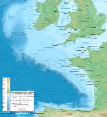
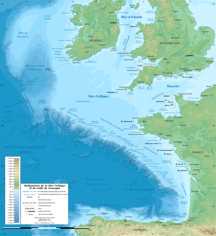
English: Bathymetric map in French of the Celtic Sea and the Bay of Biscay. Limits of the seas as specified by the International Hydrographic Organization.
Note: the background map is a raster image embedded in the SVG file. Français : Carte bathymétrique en français de la Mer Celtique et du Golfe de Gascogne. Limites des mers telles que définies par l'Organisation Hydrographique Internationale. Note : le fond de carte est une image bitmap embarquée dans le fichier SVG.
|
||
| Datum | januar 2011, upgraded 2019-10 | ||
| Izvor |
Vlastito djelo
|
||
| Autor | Eric Gaba (Sting - fr:Sting) | ||
| Dopuštenje (Naknadno korištenje ove datoteke) |
|
||
| Ostale verzije |
[]
|
||
| SVG genesis |


| Camera location | | View this and other nearby images on: OpenStreetMap |
|---|
Licenciranje
Eric Gaba (Wikimedia Commons user Sting), vlasnik autorskog prava ovog djela, ovdje ga objavljujem pod sljedećom licencom:
Ova datoteka je licencirana pod Creative Commons Attribution-Share Alike 3.0 neportiranom licencom.
Pripisivanje: Eric Gaba (Wikimedia Commons user Sting)
- Slobodni ste:
- da dijelite – da kopirate, distributirate i prenosite djelo
- da remiksate – da prilagodite djelo
- Pod sljedećim uslovima:
- pripisivanje – Morate pripisati odgovarajuće autorske zasluge, osigurati link ka licenci i naznačiti jesu li napravljene izmjene. To možete uraditi na bilo koji razumni način, ali ne tako da se sugerira da davalac licence odobrava Vas ili Vašu upotrebu njegovog djela.
- dijeli pod istim uslovima – Ako mijenjate, transformišete ili nadograđujete ovaj materijal, morate ga objaviti i distribuirati samo pod istom ili sličnom licencom poput ove.
Historija datoteke
Kliknite na datum/vrijeme da vidite verziju datoteke iz tog vremena.
| Datum/vrijeme | Smanjeni pregled | Dimenzije | Korisnik | Komentar | |
|---|---|---|---|---|---|
| trenutno | 15:11, 4 novembar 2019 | | 3.478 × 3.804 (4,93 MB) | Sting | Correction of a name |
| 22:56, 28 oktobar 2019 |  | 3.478 × 3.804 (4,92 MB) | Sting | New map using GEBCO 15 Sec topographic data ; rivers from ECRINS ; added names | |
| 20:15, 24 januar 2011 |  | 1.749 × 1.913 (613 KB) | Sting | A few more names | |
| 18:54, 23 januar 2011 |  | 1.749 × 1.913 (610 KB) | Sting | Added maritim features names | |
| 05:26, 23 januar 2011 |  | 1.749 × 1.913 (559 KB) | Sting | == {{int:filedesc}} == {{Information |Description={{en|Bathymetric map in French of the Celtic Sea and the Bay of Biscay.<br/> ''Note: the background map is a raster image embedded in the SVG file.''}} {{fr|Carte b |
Upotreba datoteke
Sljedeća stranica koristi ovu datoteku:
Globalna upotreba datoteke
Sljedeći wikiji koriste ovu datoteku:
- Upotreba na ar.wikipedia.org
- Upotreba na cs.wikipedia.org
- Upotreba na de.wikipedia.org
- Upotreba na eo.wikipedia.org
- Upotreba na fr.wikipedia.org
- Upotreba na gv.wikipedia.org
- Upotreba na hr.wikipedia.org
- Upotreba na mr.wikipedia.org
- Upotreba na oc.wikipedia.org
- Upotreba na pl.wiktionary.org
- Upotreba na sh.wikipedia.org
- Upotreba na sr.wikipedia.org
- Upotreba na sv.wikipedia.org
- Upotreba na ta.wikipedia.org
- Upotreba na th.wikipedia.org
- Upotreba na ur.wikipedia.org
- Upotreba na www.wikidata.org