Datoteka:Austin circuit.svg

Izvorna datoteka (SVG datoteka, nominalno 2.300 × 2.300 piksela, veličina datoteke: 104 KB)
| Ova datoteka je s Wikimedia Commonsa. Opis s njene stranice opisa datoteke prikazan je ispod. Commons je skladište slobodnih medija i datoteka za sve projekte fondacije Wikimedia. Možete i Vi pomoći. |
Sažetak
| Opis |
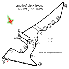
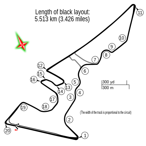
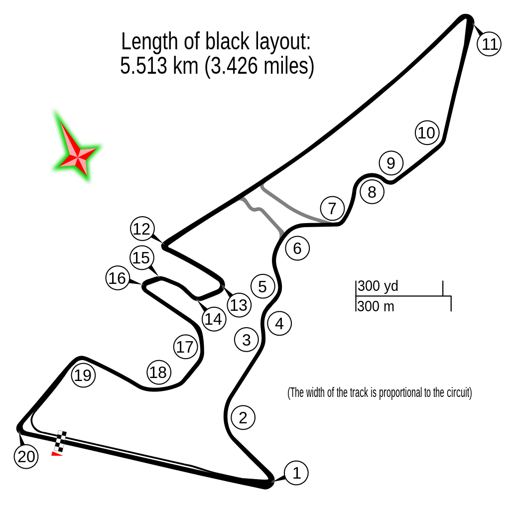
English: Circuit Austin |
| Datum | |
| Izvor | Vlastito djelo |
| Autor |
Gustavo Girardelli This W3C-unspecified vector image was created with Inkscape . |
| Ostale verzije |
|
.svg)
| Description |
This map was created from OpenStreetMap project data, collected by the community. This map may be incomplete, and may contain errors. Don't rely solely on it for navigation. |
|||
| Datum | (see file history) | |||
| Izvor | openstreetmap.org | |||
| Stvaralac |
OpenStreetMap contributors |
|||
| Dopuštenje (Naknadno korištenje ove datoteke) |
OpenStreetMap data is available under the Open Database License (details). Map tiles are licensed under the Creative Commons Attribution-ShareAlike 2.0 license (CC-BY-SA 2.0).
Ova datoteka je licencirana pod Creative Commons Attribution-Share Alike 2.0 generičkom licencom.
|
|||
| Georeferencing | If inappropriate please set warp_status = skip to hide. |
| Camera location | | View this and other nearby images on: OpenStreetMap |
|---|
Historija datoteke
Kliknite na datum/vrijeme da vidite verziju datoteke iz tog vremena.
| Datum/vrijeme | Smanjeni pregled | Dimenzije | Korisnik | Komentar | |
|---|---|---|---|---|---|
| trenutno | 12:06, 27 april 2022 | | 2.300 × 2.300 (104 KB) | DeFacto | Replaced "mi" with "miles" as that abbreviation is not in common use, especially in British English |
| 14:19, 24 oktobar 2017 |  | 2.300 × 2.300 (103 KB) | Cherkash | decimal point instead of comma | |
| 08:10, 22 oktobar 2017 |  | 2.300 × 2.300 (103 KB) | Cherkash | removed a strange artifact in rendering | |
| 07:56, 22 oktobar 2017 |  | 2.300 × 2.300 (103 KB) | Cherkash | fixed length, removed unnecessary text | |
| 08:29, 16 oktobar 2014 |  | 2.300 × 2.300 (109 KB) | Gustavo Girardelli | User created page with UploadWizard |
Upotreba datoteke
Sljedećih 9 stranica koristi ovu datoteku:
Globalna upotreba datoteke
Sljedeći wikiji koriste ovu datoteku:
- Upotreba na af.wikipedia.org
- Verenigde State Grand Prix
- Lys van Formule Een-bane
- Circuit of the Americas
- 2015 Verenigde State Grand Prix
- 2014 Verenigde State Grand Prix
- 2013 Verenigde State Grand Prix
- 2016 Verenigde State Grand Prix
- 2017 Verenigde State Grand Prix
- 2018 Verenigde State Grand Prix
- 2019 Verenigde State Grand Prix
- 2021 Verenigde State Grand Prix
- 2022 Verenigde State Grand Prix
- 2023 Verenigde State Grand Prix
- Upotreba na ar.wikipedia.org
- حلبة الأمريكتين
- جائزة الولايات المتحدة الكبرى 2015
- جائزة الولايات المتحدة الكبرى 2014
- جائزة الولايات المتحدة الكبرى 2013
- جائزة الولايات المتحدة الكبرى 2017
- جائزة الولايات المتحدة الكبرى 2016
- جائزة الولايات المتحدة الكبرى 2018
- جائزة الولايات المتحدة الكبرى 2012
- جائزة الولايات المتحدة الكبرى 2019
- جائزة الولايات المتحدة الكبرى
- جائزة الولايات المتحدة الكبرى 2021
- جائزة الولايات المتحدة الكبرى 2022
- جائزة الولايات المتحدة الكبرى 2023
- Upotreba na ast.wikipedia.org
- Upotreba na bg.wikipedia.org
- Upotreba na bn.wikipedia.org
- Upotreba na br.wikipedia.org
- Upotreba na ca.wikipedia.org
Pogledajte globalne upotrebe ove datoteke.