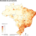
Datoteka:ARCHELLA E THERY Img 05.png

Veličina ovog prikaza: 590 × 600 piksela. Ostale rezolucije: 236 × 240 piksela | 593 × 603 piksela.
Izvorna datoteka (593 × 603 piksela, veličina datoteke: 214 KB, MIME tip: image/png)
Historija datoteke
Kliknite na datum/vrijeme da vidite verziju datoteke iz tog vremena.
| Datum/vrijeme | Smanjeni pregled | Dimenzije | Korisnik | Komentar | |
|---|---|---|---|---|---|
| trenutno | 23:02, 13 februar 2009 |  | 593 × 603 (214 KB) | Andremalms | {{Information |Description={{pt|1=http://confins.revues.org/document3483.html}} |Source=Revista disponível na web; http://confins.revues.org/document3483.html |Author=ARCHELLA & THÉRY, 2008 |Date=2008 |Permission= |other_versions= }} <!--{{ImageUpload| |
Upotreba datoteke
Sljedeća stranica koristi ovu datoteku:
Globalna upotreba datoteke
Sljedeći wikiji koriste ovu datoteku:
- Upotreba na ar.wikipedia.org
- Upotreba na be.wikipedia.org
- Upotreba na bg.wikipedia.org
- Upotreba na cs.wikipedia.org
- Upotreba na de.wikipedia.org
- Upotreba na eu.wikipedia.org
- Upotreba na fr.wikipedia.org
- Upotreba na he.wikipedia.org
- Upotreba na hu.wikipedia.org
- Upotreba na hyw.wikipedia.org
- Upotreba na io.wikipedia.org
- Upotreba na lv.wikipedia.org
- Upotreba na mk.wikipedia.org
- Upotreba na nds-nl.wikipedia.org
- Upotreba na pt.wikipedia.org
- Upotreba na te.wikipedia.org
- Upotreba na uk.wikipedia.org
- Upotreba na zh.wikipedia.org
