Datoteka:Kangshung-06.PNG

Veličina ovog prikaza: 800 × 526 piksela. Ostale rezolucije: 320 × 210 piksela | 640 × 421 piksela | 1.157 × 761 piksela.
Izvorna datoteka (1.157 × 761 piksela, veličina datoteke: 1,95 MB, MIME tip: image/png)
| Ova datoteka je s Wikimedia Commonsa. Opis s njene stranice opisa datoteke prikazan je ispod. Commons je skladište slobodnih medija i datoteka za sve projekte fondacije Wikimedia. Možete i Vi pomoći. |
Sažetak
| Opis |
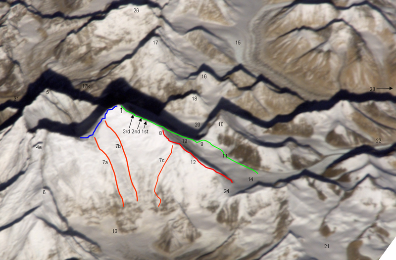
Deutsch: Ost- (Kangshung-) Wand des Mount Everest mit Umgebung |
|
| Datum | 12 novembar 2008 (original upload date) | |
| Izvor | Transferred from de.wikipedia to Commons by Rupert Pupkin using CommonsHelper. | |
| Autor |
Fotografija: NASA |
|
| Ostale verzije |
|


Notes
| green line | Normal route, mainly the Mallory route 1924, via high camps on 7700 and 8300 m, via "yellow band", exit cracks & upper NE ridge w. "Second Step") |
| red line / no.12 | lower and middle NE ridge |
| blue line | upper SE ridge (part of the «Hillary route» 1953 etc. coming from Western Qwm (in the shadow behind Mt. Everest) meeting point with the orange route 7a is the south col meeting point with the orange route 7b is the balcony |
| orange line 7a | 1988 US and GB ascent (Stephen Vernables et al.) |
| orange line 7b | 1982 US ascent (Carlos Buhler, Kim Momb et al.) |
| orange line 7c | “Phantasy Ridge” (acc. to a speech of George Mallory), no successful ascent until 2008, tried by Cathy O’Dowd and Ian Woodall; they came half way to NE ridge & Pinnacles |
| 1 | summit of Mount Everest 8848m |
| 3rd 2nd 1st | steps on the Upper NE ridge 8700m, 8605m and 8530m |
| 4e | Lhotse Shar |
| 5 | Nuptse |
| 6 | “Peak 38” |
| 13 | Kangshung Glacier |
| 8 | “Three Pinnacles” where Joe Tasker and Peter Boardman died 1982 (2nd pinnacle) |
| 9 | North Col on 7050m |
| 14 | East Rongbuk Glacier |
| 10 | Changtse (northern summit) |
| 11 | ABC Advanced Base Camp (North) on the upper East Rongbuk Glacier in front of the ice wall to north col |
| 15 | West Rongbuk Glacier (coming from the Cho Oyu and Gyachung Kang flanks) |
| 16 | Lingtren |
| 17 | Pumori |
| 17k | Kala Patthar, “Everest Trekking View Point” from the south side |
| 18 | Khumbutse (summit west of Lho La which is the connection on 6006m of the glacier systems of Rongbu and Khumbu and is also the tibetian-nepalian borderline / like SE ridge & W ridge. Lho La is "foot point" of the Everest W ridge.) |
| 19 | north ridge // below of fig. 19 the Zakharov Couloir offering a tough ascent to NE ridge without going via north col |
| 20 | Main Rongbuk Glacier |
| 21 | upper Kharta Glacier (Mallory 1921, where discovered the access to North Col) |
| 22 | Camp II of the early british expeditions 1922+1924 |
| 23 | to the Base camp on foot of the Main Rongbuk Glacier and to Rongbuk Gompa (Monastery) |
| 24 | Rapiu La (connection from Eastern Rongbuk Glacier System to Kangshung Glacier System) |
Licenciranje
Original photograph:
| This file is in the public domain in the United States because it was solely created by NASA. NASA copyright policy states that "NASA material is not protected by copyright unless noted". (See Template:PD-USGov, NASA copyright policy page or JPL Image Use Policy.) |
Lines and points:
Kassander der Minoer at njemački Wikipedia, vlasnik autorskog prava ovog djela, ovdje ga objavljujem pod sljedećom licencom:

|
Dozvoljeno je kopirati, distribuirati i/ili mijenjati ovaj članak pod uslovima navedenim u GNU licenci za slobodnu dokumentaciju, verzija 1.2 ili kasnijom verzijom izdatom od Free Software Foundation; bez nepromjenljivih dijelova, te bez sadržaja na naslovnoj i zadnjoj strani. Kopija licence se nalazi pod poglavljem GNU Free Documentation License. |
| Ova datoteka je licencirana pod Creative Commons Attribution-Share Alike 3.0 neportiranom licencom. | ||
| Pripisivanje: Kassander der Minoer at njemački Wikipedia | ||
| ||
| Ova oznaka licence je dodana na ovu datoteku kao dio GFDL ažuriranja licence. |
Originalni zapisnik postavljanja
The original description page was here. All following user names refer to de.wikipedia.
- 2008-11-12 20:39 Kassander der Minoer 1157×761× (2046200 bytes) {{Information |Beschreibung = Ost- (Kangshung-) Wand des Mount Everest mit Umgebung |Quelle = NASA & eigene Arbeit (Linien und Punkte markiert) |Urheber = NASA |Datum = 12.11.2008 |Genehmigung = US-Gov-GFDL |Andere Versionen = |Anmerkungen = }}
Historija datoteke
Kliknite na datum/vrijeme da vidite verziju datoteke iz tog vremena.
| Datum/vrijeme | Smanjeni pregled | Dimenzije | Korisnik | Komentar | |
|---|---|---|---|---|---|
| trenutno | 23:59, 26 novembar 2008 | | 1.157 × 761 (1,95 MB) | File Upload Bot (Magnus Manske) | {{BotMoveToCommons|de.wikipedia}} {{Information |Description={{de|Ost- (Kangshung-) Wand des Mount Everest mit Umgebung}} |Source=Transferred from [http://de.wikipedia.org de.wikipedia]; transferred to Commons by User:Rupert Pupkin using [http://tool |
Upotreba datoteke
Sljedeća stranica koristi ovu datoteku:
Globalna upotreba datoteke
Sljedeći wikiji koriste ovu datoteku:
- Upotreba na az.wikipedia.org
- Upotreba na de.wikipedia.org
- Upotreba na en.wikipedia.org
- Upotreba na es.wikipedia.org
- Upotreba na fr.wikipedia.org
- Upotreba na ro.wikipedia.org
- Upotreba na ru.wikipedia.org
- Upotreba na uk.wikipedia.org
- Upotreba na www.wikidata.org
- Upotreba na zh.wikipedia.org