Datoteka:KK Boat Drop-Off.jpg
Veličina ovog prikaza: 800 × 531 piksela. Ostale rezolucije: 320 × 213 piksela | 640 × 425 piksela | 1.024 × 680 piksela | 1.280 × 850 piksela | 2.560 × 1.700 piksela | 4.288 × 2.848 piksela.
Izvorna datoteka (4.288 × 2.848 piksela, veličina datoteke: 10,31 MB, MIME tip: image/jpeg)
| Ova datoteka je s Wikimedia Commonsa. Opis s njene stranice opisa datoteke prikazan je ispod. Commons je skladište slobodnih medija i datoteka za sve projekte fondacije Wikimedia. Možete i Vi pomoći. |
This image has been assessed using the Quality image guidelines and is considered a Quality image.
|
Sažetak
| Opis |
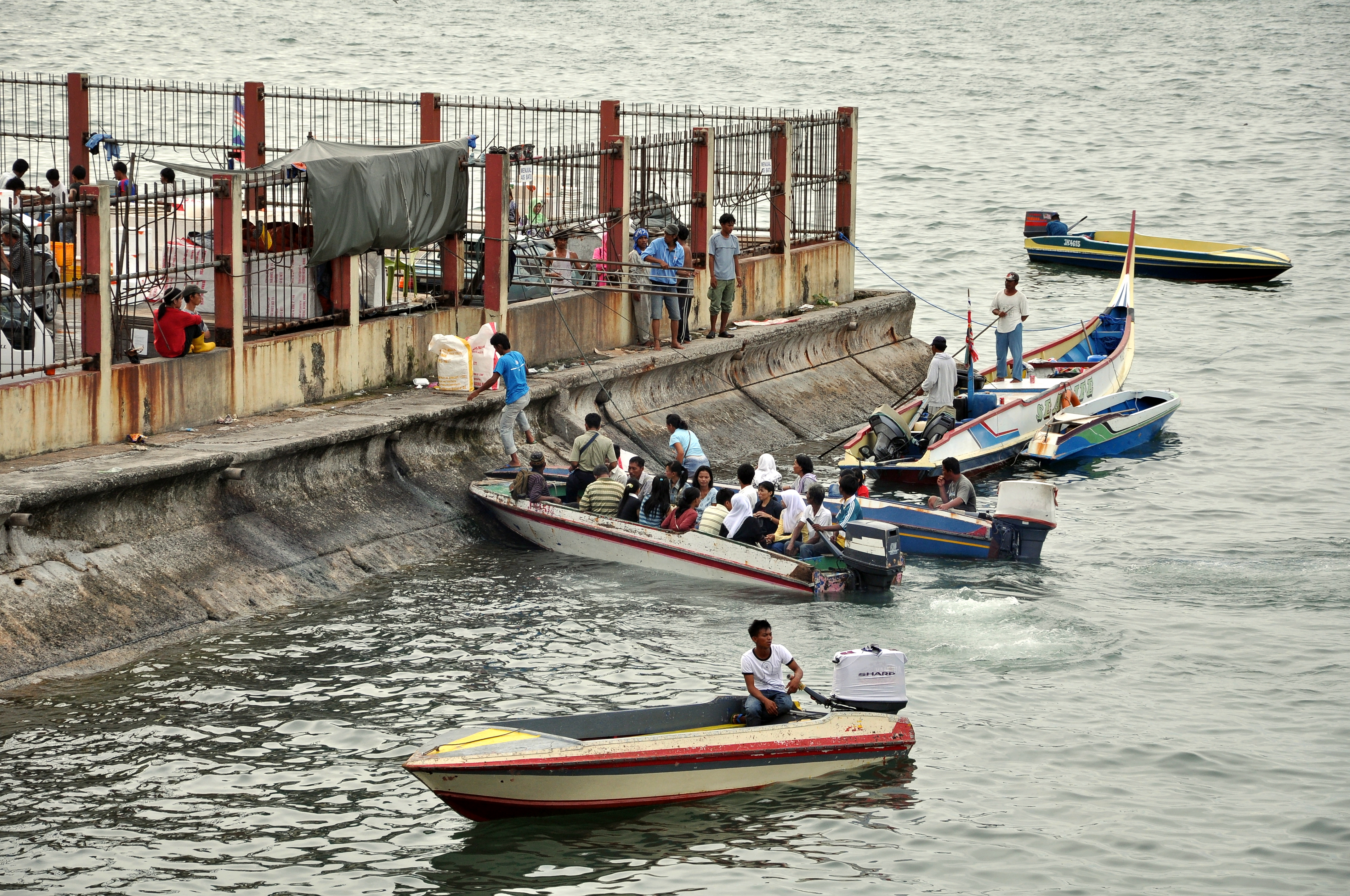
English: Side of the Fish Market in Kota Kinabalu used as pick-up and drop-off for trips to and from the Gaya island Filipino (refugee) water village. It is next to a Jetty (seen here, here, and here ), but apparently the boat traffic is too heavy and more space is needed. Notice the holes that have been made on the fence to get through. State of Sabah, in Malaysia.
Español: Lateral del mercado de pescado en Kota Kinabalu usado como muelle improvisado ya que el trafico es tan grande que el muelle original (que esta en frente y se puede ver aqui, aqui, y aqui) no da abasto. Este punto de embarque es usado para ir a el pueblo de refugiados filipinos en la isla de Gaya (frente a Kota Kinabalu). Se pueden observar varios agujeros en la verja que han hecho la gente para acceder a la zona. Estado de Sabah, en Malasia.
Français : Zone en bordure du marché aux poissons de Kota Kinabalu servant aux départs et arrivées vers ou depuis le village philippin de l'île de Gaya. Elle se trouve non loin d'une jetée, mais le trafic maritime est apparemment trop chargé et la place manque. Des passages ont été aménagés dans la barrière. État de Sabah, en Malaisie. |
| Datum | |
| Izvor | Vlastito djelo |
| Autor | Dcubillas |
| Camera location | | View this and other nearby images on: OpenStreetMap |
|---|

|
Although this work is freely licensed or in the public domain, the person(s) shown may have rights that legally restrict certain re-uses unless those depicted consent to such uses. In these cases, a model release or other evidence of consent could protect you from infringement claims. Though not obliged to do so, the uploader may be able to help you to obtain such evidence. See our general disclaimer for more information. |
Licenciranje
Ja, vlasnik autorskog prava ovog djela, ovdje ga objavljujem pod sljedećim licencama:
Ova datoteka je licencirana pod Creative Commons Attribution-Share Alike 3.0 neportiranom licencom.
- Slobodni ste:
- da dijelite – da kopirate, distributirate i prenosite djelo
- da remiksate – da prilagodite djelo
- Pod sljedećim uslovima:
- pripisivanje – Morate pripisati odgovarajuće autorske zasluge, osigurati link ka licenci i naznačiti jesu li napravljene izmjene. To možete uraditi na bilo koji razumni način, ali ne tako da se sugerira da davalac licence odobrava Vas ili Vašu upotrebu njegovog djela.
- dijeli pod istim uslovima – Ako mijenjate, transformišete ili nadograđujete ovaj materijal, morate ga objaviti i distribuirati samo pod istom ili sličnom licencom poput ove.

|
Dozvoljeno je kopirati, distribuirati i/ili mijenjati ovaj članak pod uslovima navedenim u GNU licenci za slobodnu dokumentaciju, verzija 1.2 ili kasnijom verzijom izdatom od Free Software Foundation; bez nepromjenljivih dijelova, te bez sadržaja na naslovnoj i zadnjoj strani. Kopija licence se nalazi pod poglavljem GNU Free Documentation License. |
Možete odabrati licencu po vašem izboru.
Historija datoteke
Kliknite na datum/vrijeme da vidite verziju datoteke iz tog vremena.
| Datum/vrijeme | Smanjeni pregled | Dimenzije | Korisnik | Komentar | |
|---|---|---|---|---|---|
| trenutno | 00:04, 11 januar 2009 | | 4.288 × 2.848 (10,31 MB) | Dcubillas | {{Information |Description={{en|1=Side of the Fish Market in Kota Kinabalu used as pick-up and drop-off for trips to and from the Gaya island Filipino village. It is next to a Jetty, but apparently the boat traffic is too heavy and more space is needed. H |
Upotreba datoteke
Sljedeća stranica koristi ovu datoteku:
Globalna upotreba datoteke
Sljedeći wikiji koriste ovu datoteku:
- Upotreba na ast.wikipedia.org
- Upotreba na es.wikipedia.org
- Upotreba na fr.wikipedia.org
- Upotreba na ko.wikipedia.org
- Upotreba na ru.wiktionary.org
- Upotreba na ur.wikipedia.org