Datoteka:Iraqi Kurdistan in Iraq (de-facto and disputed hatched).svg

Veličina ovog PNG pregleda za ovu SVG datoteku: 589 × 600 piksela. Ostale rezolucije: 236 × 240 piksela | 471 × 480 piksela | 754 × 768 piksela | 1.005 × 1.024 piksela | 2.011 × 2.048 piksela | 1.241 × 1.264 piksela.
Izvorna datoteka (SVG datoteka, nominalno 1.241 × 1.264 piksela, veličina datoteke: 545 KB)
| Ova datoteka je s Wikimedia Commonsa. Opis s njene stranice opisa datoteke prikazan je ispod. Commons je skladište slobodnih medija i datoteka za sve projekte fondacije Wikimedia. Možete i Vi pomoći. |
Sažetak
| Opis |
閩南語 / Bân-lâm-gú: Kurdistan tī Iraq ê ūi-tì
Iraq koaⁿ-hong tēng ê Kurdistan Tē-he̍k Iraq Kurdistan khòng-chè ê thó͘-tē Iraq Kurdistan chú-tiuⁿ ê thó͘-tē Iraq kî-tha pō͘-hūn Català: Kurdistan Iraquí
Límits oficials de la regió kurda Territori controlat pel Kurdistan Iraquí Territory reivindicat pel Kurdistan Iraquí Dansk: Kort over Irakisk Kurdistan i Irak
Officielle grænser for Regionen Irakisk Kurdistan Andre områder kontrolleret af Irakisk Kurdistan Territorier som Irakisk Kurdistan gør krav på Øvrige Irak Deutsch: Die Lage Kurdistans im Irak
Offizielles Gebiet der Autonomen Region Kurdistan Eingegliederte Gebiete (nicht offiziell anerkannt) Von der Autonomen Region Kurdistans beanspruchte und besetzte Gebiete Von der Autonomen Region Kurdistans beanspruchte Gebiete Der Rest des Iraks Grenzen der Autonomen Region Kurdistans (inkl. der eingegliederten Gebiete) Grenze vor 2014 English: Location of Kurdistan in Iraq
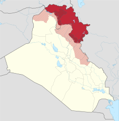
Borders of the Kurdistan Region (disputed) Pre-2014 borders Recognised territory of the Kurdistan Region Disputed territory incorporated into the Kurdistan Region Other territory claimed and controlled by the Kurdistan Regional Government (approximate) Other territory claimed by the Kurdistan Regional Government Rest of Iraq Español: Ubicación de Kurdistan Iraquí
Fronteras oficiales de la región. Territorio ocupado por el Kurdistan Iraquí Territorio reclamado por el Kurdistan Iraquí. El resto de Irak. Français : Le Kurdistan irakien en Irak
Frontières officielles du Kurdistan irakien Territoire incorporé par le Kurdistan irakien Territoire revendiqué par le Kurdistan irakien Reste de l'Irak Italiano: Ubicazione del Kurdistan in Iraq
Confini della Regione del Kurdistan (contesi) Confini precedenti al 2014 Territorio riconosciuto ufficialmente della Regione del Kurdistan Territorio conteso incorporato nella Regione del Kurdistan Altri territori reclamati e amministrati dal governo regionale curdo (approssimativi) Altri territori reclamati dal governo regionale curdo Il resto dell'Iraq Magyar: Iraki Kurdisztán területe Irakon belül
Iraki Kurdisztán hivatalos területe a kurdok által elfoglalt terület (nem hivatalos) Iraki Kurdisztán által igényelt és elfoglalt terület Iraki Kurdisztán által igényelt terület Irak maradék területe Kurdisztáni Autonóm Régió határa A határ 2014 előtt Nederlands: Ligging van Koerdistan in Irak
Officiële grondgebied van Iraaks-Koerdistan Gebied ingelijfd door Iraaks-Koerdistan Gebied opgeëist door Iraaks-Koerdistan Overig Irak Suomi: Kurdistanin sijainti Irakissa
Irakin Kurdistanin autonominen alue Irakin Kurdistaniin kuuluvat alueet Irakin Kurdistanin vaatimat alueet Irakin valtion hallitsemat alueet Русский: Курдистан на карте Ирака
Официальные границы автономного региона Иракский Курдистан Территория, контролируемая силами Иракского Курдистана Территория, на которую претендует Иракский Курдистан Прочие территории Ирака 日本語: イラク領クルド人自治区 イラク
イラク中央政府が公式に定めたクルド人自治区の領域 イラク・クルド自治政府が併合し実効支配している領域 イラク・クルド自治政府が領有を主張する領域 その他のイラク国土 فارسی : اقلیم کردستان عراق
منطقهٔ رسمی کردستان عراق (در دست دولت کردستان) بخشهای اشغالشده توسط کردستان عراق دیگر بخشهای موردادعای کردستان عراق (در دست دولت مرکزی یا در اشغال داعش) دیگر منطقههای عراق |
||||
| Datum | |||||
| Izvor | |||||
| Autor |
Spesh531, TUBS |
||||
| Ostale verzije |
|
||||
| SVG genesis | |||||
.svg)
.svg)
.svg)
.svg)
.svg)
.svg)
.svg)

-en.svg)

.svg)
.svg)
.svg)

_(US48).svg)
_(small_islands_magnified)_(-mini_map_-rivers).svg)
.svg)
_(extra_close)_(US48).svg)
.svg)
_(zoom).svg)

.svg)


_(UNMIK).svg)
.svg)
_(disputed_hatched).svg)
_(claimed_and_disputed_hatched).svg)
.svg)
.svg)
_(%2Ball_claims_hatched).svg)

.svg)
_(shade).svg)
_(shade)_(special_marker).svg)
_(-mini_map).svg)
_(-mini_map).svg)
_(-mini_map).svg)


.svg)

.svg)
.svg)
Licenciranje
Ova datoteka je licencirana pod Creative Commons Attribution-Share Alike 3.0 neportiranom licencom.
- Slobodni ste:
- da dijelite – da kopirate, distributirate i prenosite djelo
- da remiksate – da prilagodite djelo
- Pod sljedećim uslovima:
- pripisivanje – Morate pripisati odgovarajuće autorske zasluge, osigurati link ka licenci i naznačiti jesu li napravljene izmjene. To možete uraditi na bilo koji razumni način, ali ne tako da se sugerira da davalac licence odobrava Vas ili Vašu upotrebu njegovog djela.
- dijeli pod istim uslovima – Ako mijenjate, transformišete ili nadograđujete ovaj materijal, morate ga objaviti i distribuirati samo pod istom ili sličnom licencom poput ove.
References
Official territory and governorate borders
- http://www.krso.net/Default.aspx?page=article&id=1142
- http://www.economist.com/images/20070908/CMA980.gif
Claimed territory
- http://www.aina.org/reports/pcok.pdf (page 13)
- http://www.economist.com/images/20070908/CMA980.gif
- http://photos1.blogger.com/blogger/6564/131/1600/Kurdistan_july05_claimed-767346.jpg
- http://images.fastcompany.com/magazine/144/feature-84-Kurdistan-OilMap-pop.jpg
- http://news.bbcimg.co.uk/media/images/76876000/gif/_76876578_iraq_kurdistan_624.gif
Historija datoteke
Kliknite na datum/vrijeme da vidite verziju datoteke iz tog vremena.
.svg&dir=prev)
.svg&offset=20170928132057)
.svg&offset=&limit=20)
.svg&offset=&limit=50)
.svg&offset=&limit=100)
.svg&offset=&limit=250)
.svg&offset=&limit=500)
| Datum/vrijeme | Smanjeni pregled | Dimenzije | Korisnik | Komentar | |
|---|---|---|---|---|---|
| trenutno | 01:01, 20 juli 2018 | | 1.241 × 1.264 (545 KB) | Rob984 | dashed official KRG border on the basis that it's disputed by Baghdad. |
| 21:05, 19 juli 2018 |  | 1.241 × 1.264 (548 KB) | Rob984 | Also Iraqi forces took Khanaqin in October as well | |
| 20:12, 19 juli 2018 |  | 1.241 × 1.264 (549 KB) | Rob984 | The town of Makhmur was taken over by Iraqi forces last year. Also the frontier in Kirkuk likely corresponds to the 2003 green line, not the administrative border, since Iraq only requested the Kurdish forces withdraw to the green line. | |
| 00:34, 27 januar 2018 |  | 1.241 × 1.264 (549 KB) | 0ali1 | Update 26/01/2018, minor fixes | |
| 01:55, 25 oktobar 2017 |  | 1.241 × 1.264 (549 KB) | Rob984 | Federal government has reassumed control over most (if not all) of the Kirkuk province. | |
| 18:03, 24 oktobar 2017 |  | 1.241 × 1.264 (549 KB) | Rob984 | Scaled back changes around Machmur. Peshmerga have not withdrawn from the town, despite earlier reports suggesting so. | |
| 14:26, 20 oktobar 2017 |  | 1.241 × 1.264 (549 KB) | Rob984 | Update following Peshmerga withdrawal from a number of areas. Note Kurdish militias (eg PKK, YBS, etc.) have not withdrew from all areas, but they are not under KRG control. Approximate area, will need to be updated. | |
| 22:20, 12 oktobar 2017 |  | 1.241 × 1.264 (555 KB) | Spesh531 | Update now that ISIS is no longer on the Iraqi Kurdish-Iraqi proper border | |
| 16:28, 28 septembar 2017 |  | 1.241 × 1.264 (555 KB) | Rob984 | another minor fix | |
| 15:20, 28 septembar 2017 |  | 1.241 × 1.264 (555 KB) | Rob984 | minor fix |
Upotreba datoteke
Sljedeća stranica koristi ovu datoteku:
Globalna upotreba datoteke
Sljedeći wikiji koriste ovu datoteku:
- Upotreba na als.wikipedia.org
- Upotreba na ar.wikipedia.org
- Upotreba na arz.wikipedia.org
- Upotreba na azb.wikipedia.org
- Upotreba na az.wikipedia.org
- Upotreba na ba.wikipedia.org
- Upotreba na bcl.wikipedia.org
- Upotreba na be-tarask.wikipedia.org
- Upotreba na be.wikipedia.org
- Upotreba na bg.wikipedia.org
- Upotreba na bn.wikipedia.org
- Upotreba na br.wikipedia.org
- Upotreba na ceb.wikipedia.org
- Upotreba na ckb.wikipedia.org
- Upotreba na cs.wikipedia.org
- Upotreba na cy.wikipedia.org
- Upotreba na da.wikipedia.org
- Upotreba na de.wikipedia.org
- Upotreba na diq.wikipedia.org
- Upotreba na el.wikipedia.org
- Upotreba na el.wikivoyage.org
- Upotreba na en.wikipedia.org
- Iraqi Kurdistan
- Minorities in Iraq
- 2008 Turkish incursion into northern Iraq
- List of active separatist movements in Asia
- Disputed territories of northern Iraq
- Northern Iraq offensive (June 2014)
- Talk:Iraqi Kurdistan/Archive 2
- Ba'athist Arabization campaigns in northern Iraq
- COVID-19 pandemic in the Kurdistan Region
- Upotreba na eo.wikipedia.org
- Upotreba na es.wikipedia.org
Pogledajte globalne upotrebe ove datoteke.
.svg)
.svg)