Datoteka:Formative Period southern Mesoamerica 2.svg

Veličina ovog PNG pregleda za ovu SVG datoteku: 800 × 380 piksela. Ostale rezolucije: 320 × 152 piksela | 640 × 304 piksela | 1.024 × 486 piksela | 1.280 × 608 piksela | 2.560 × 1.215 piksela | 1.241 × 589 piksela.
Izvorna datoteka (SVG datoteka, nominalno 1.241 × 589 piksela, veličina datoteke: 252 KB)
| Ova datoteka je s Wikimedia Commonsa. Opis s njene stranice opisa datoteke prikazan je ispod. Commons je skladište slobodnih medija i datoteka za sve projekte fondacije Wikimedia. Možete i Vi pomoći. |
Sažetak
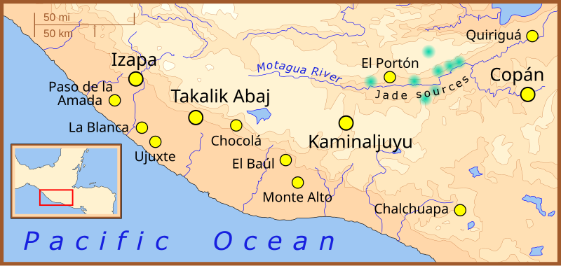
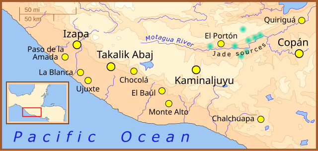
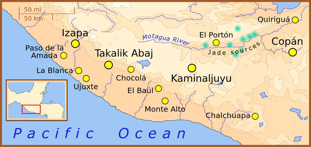
| Opis | A map of the southern-most area of Mesoamerica, showing important Formative Period sites. |
| Datum | |
| Izvor | Vlastito djelo |
| Autor | Madman2001 |
References
- Jadeite locations taken from: Lallemant, Hans G. Avé "Petrogenisis and Exhumation of Jadeitites in Guatemala", Rice University, accessed February 2008.
- Elevations based on those in the Times Atlas of the World, 7th edition.
- Location of archaeological sites taken from map for the upcoming book: "The Southern Maya Area in the Late Preclassic: Urbanism, Rulership, and Ethnic Interaction.", in press at the University Press of Colorado, Boulder, Michael Love and Jonathan Kaplan, eds.
Licenciranje
Ja, vlasnik autorskog prava ovog djela, ovdje ga objavljujem pod sljedećom licencom:
Ova datoteka je licencirana pod Creative Commons Attribution-Share Alike 3.0 neportiranom licencom.
- Slobodni ste:
- da dijelite – da kopirate, distributirate i prenosite djelo
- da remiksate – da prilagodite djelo
- Pod sljedećim uslovima:
- pripisivanje – Morate pripisati odgovarajuće autorske zasluge, osigurati link ka licenci i naznačiti jesu li napravljene izmjene. To možete uraditi na bilo koji razumni način, ali ne tako da se sugerira da davalac licence odobrava Vas ili Vašu upotrebu njegovog djela.
- dijeli pod istim uslovima – Ako mijenjate, transformišete ili nadograđujete ovaj materijal, morate ga objaviti i distribuirati samo pod istom ili sličnom licencom poput ove.
Historija datoteke
Kliknite na datum/vrijeme da vidite verziju datoteke iz tog vremena.
| Datum/vrijeme | Smanjeni pregled | Dimenzije | Korisnik | Komentar | |
|---|---|---|---|---|---|
| trenutno | 03:22, 9 februar 2008 | | 1.241 × 589 (252 KB) | Madman2001 | Fixed mistake and added another site |
| 20:04, 7 februar 2008 |  | 1.241 × 589 (252 KB) | Madman2001 | fixed earlier mistake | |
| 19:41, 7 februar 2008 |  | 1.241 × 589 (224 KB) | Madman2001 | smaller formating changes | |
| 15:14, 7 februar 2008 |  | 1.241 × 589 (234 KB) | Madman2001 | {{Information |Description=A map of the southern-most area of Mesoamerica, showing important Formative Period sites. |Source=self-made |Date=February 2008 |Author= Madman2001 |Permission= |other_versions= }} |
Upotreba datoteke
Sljedeća stranica koristi ovu datoteku:
Globalna upotreba datoteke
Sljedeći wikiji koriste ovu datoteku:
- Upotreba na af.wikipedia.org
- Upotreba na ar.wikipedia.org
- Upotreba na be.wikipedia.org
- Upotreba na de.wikipedia.org
- Upotreba na en.wikipedia.org
- Upotreba na es.wikipedia.org
- Upotreba na fi.wikipedia.org
- Upotreba na fi.wikibooks.org
- Upotreba na fr.wikipedia.org
- Upotreba na he.wikipedia.org
- Upotreba na hr.wikipedia.org
- Upotreba na hu.wikipedia.org
- Upotreba na id.wikipedia.org
- Upotreba na it.wikipedia.org
- Upotreba na ja.wikipedia.org
- Upotreba na ka.wikipedia.org
- Upotreba na lt.wikipedia.org
- Upotreba na nl.wikipedia.org
- Upotreba na pt.wikipedia.org
- Upotreba na ru.wikipedia.org
- Upotreba na sh.wikipedia.org
Pogledajte globalne upotrebe ove datoteke.